Kieler, WI.
73 deg. overcast, NE wind @ 10 mph
Forecast = Occasional showers and thunderstorms early in the morning...Then mostly cloudy with a chance of showers and thunderstorms in the late morning and afternoon. Highs in the upper 80s. East winds 5 to 10 mph. Chance of rain 100 percent. Highest heat index readings 95 to 100 in the afternoon.
By the time Jim got me pulled out of my site, had CLT hooked to the back of me and dumped my very full tanks, it was 9:55. A right turn out of the CG put us on WI 80, which took us to I-90 where we turned South and followed it to just South of Lake Delton. There, we turned off on US 12 and followed it down to Sauk City where we turned off of 12 and took WI 78 down to Mount Horeb.
Now, if any of you are planning on coming through this area, I strongly advise against taking WI 78!!!
It was one of the roughest roads I've been on in a long time, especially the southern part between Black Earth and Mount Horeb!!!
Form Mount Horeb, we took US 151 to the West and followed it here to the Rustic Barn Campground and RV Park in Kieler.
It was 12:35 when we pulled up in front of the barn, so it took us 2 hours and 40 minutes to travel 137 miles.
This CG is pretty nice. I have 50 Amp electric and water hook-ups at my pull-through site, there's supposed to be Wi Fi here, but I can't get connected to it, even though I have the password. They have quite a few pull-through sites that are long enough for me and CLT, and some of the sites are shaded.
Today, we'll head down to Moscow, IA and to the HWH factory where I have an appointment at 12:30. I have no idea how long I'll be there, it all depends on what they find wrong with my leaking jack.
Did you know that July is "National Doghouse Repairs Month"?
Showing posts with label roads. Show all posts
Showing posts with label roads. Show all posts
Tuesday, July 24, 2012
Wednesday, July 11, 2012
The Gay Bar, A Rough Road but Spectacular Scenery
Ahmeek, MI
61 deg. clear, no wind.
Forecast = Sunny. Highs 77 to 82. West winds 5 to 15 mph.
By 11:00, Jim and Linda were driving out of the CG in CLT, (Cute Little Truck), and heading SE towards the opposite shore of the Keweenaw Peninsula to do a little sight seeing. Darrell, one of my faithful followers , had told Jim and Linda about the Gay Bar, (no not that kind), in Gay, Michigan.
He said that it was a good place to grab a sandwich, so Jim and Linda stopped in and had a very nice lunch. Jim had a fish sandwich and Linda had the special, the BBQ sandwich. Both were very good. : )
![]() Below is a photo of the Gay Bar from across the street. ; )
Below is a photo of the Gay Bar from across the street. ; )
![]() From Gay, they headed up along the shore, stopping now and then at little parks along the way. At this one, part of the shore was rocky,
From Gay, they headed up along the shore, stopping now and then at little parks along the way. At this one, part of the shore was rocky,
![]() but part of it was sandy, and there were people out there enjoying the water, on what was becoming a fairly warm day.
but part of it was sandy, and there were people out there enjoying the water, on what was becoming a fairly warm day.
![]() When they got up to the end of the Peninsula, they drove around in Copper Harbor a little, and then started back down the other side of the Peninsula. (The NW side).
When they got up to the end of the Peninsula, they drove around in Copper Harbor a little, and then started back down the other side of the Peninsula. (The NW side).
2 years ago, when they were here, Jim and Linda had taken the Brockway Mt. Drive and remembered it to be a very scenic route. So, being that it runs parallel to the route they had planned on taking, they took it. Well, the route is still very scenic, but the road up and down the mountain was in very bad condition!!! It is a very hilly, twisty/turny road, but the pavement is breaking up and now is very rough!! : (
Once to the top, the view is spectacular, and you can see for miles and miles in all directions, so CLT said it was probably worth the bumpy ride. They have information signs and maps pointing out things that you can see from the different viewpoints.
![]()
![]() Once down off of the mountain, they followed Rt 26 back to Eagle River, (another very scenic part of the drive along the shore),
Once down off of the mountain, they followed Rt 26 back to Eagle River, (another very scenic part of the drive along the shore),
![]() and back here to the Campground.
and back here to the Campground.
CLT said that he really enjoyed the drive, (except for the rough road going up to and coming down from Brockway Mt), and was really happy that Jim and Linda decided to go.
Tomorrow, we'll be leaving here, so I imagine the today, Jim and Linda will start getting me ready to travel. They also want to go back to Slim's and buy some more of those great bakery items that they sell there.
Oh, can you take another sunset photo? We had another pretty one last night. : )
![]() That makes #6!!!! ; )
That makes #6!!!! ; )
Did you know that The Keweenaw Peninsula and Isle Royale, formed by the Midcontinent Rift System, are the only sites in the country with evidence of prehistoric aboriginal mining of copper?
61 deg. clear, no wind.
Forecast = Sunny. Highs 77 to 82. West winds 5 to 15 mph.
By 11:00, Jim and Linda were driving out of the CG in CLT, (Cute Little Truck), and heading SE towards the opposite shore of the Keweenaw Peninsula to do a little sight seeing. Darrell, one of my faithful followers , had told Jim and Linda about the Gay Bar, (no not that kind), in Gay, Michigan.
He said that it was a good place to grab a sandwich, so Jim and Linda stopped in and had a very nice lunch. Jim had a fish sandwich and Linda had the special, the BBQ sandwich. Both were very good. : )


2 years ago, when they were here, Jim and Linda had taken the Brockway Mt. Drive and remembered it to be a very scenic route. So, being that it runs parallel to the route they had planned on taking, they took it. Well, the route is still very scenic, but the road up and down the mountain was in very bad condition!!! It is a very hilly, twisty/turny road, but the pavement is breaking up and now is very rough!! : (
Once to the top, the view is spectacular, and you can see for miles and miles in all directions, so CLT said it was probably worth the bumpy ride. They have information signs and maps pointing out things that you can see from the different viewpoints.


CLT said that he really enjoyed the drive, (except for the rough road going up to and coming down from Brockway Mt), and was really happy that Jim and Linda decided to go.
Tomorrow, we'll be leaving here, so I imagine the today, Jim and Linda will start getting me ready to travel. They also want to go back to Slim's and buy some more of those great bakery items that they sell there.
Oh, can you take another sunset photo? We had another pretty one last night. : )

Did you know that The Keweenaw Peninsula and Isle Royale, formed by the Midcontinent Rift System, are the only sites in the country with evidence of prehistoric aboriginal mining of copper?
Friday, June 8, 2012
Sprague WA to St. Regis MT
Saint Regis, MT
48 deg. cloudy, no wind.
Forecast today = Mostly cloudy with rain showers. High of 59F. Winds from the West at 5 to 10 mph. Chance of rain 70%.
Believe it or not, but we left Sprague and 8:05 yesterday morning!!!! I really didn't think we get out of there until 9 or so. : )
Once back on I-90, we simply followed it all the way here to Saint Regis, MT. and to Campground St. Regis. It was 11:45 when we pulled up to the office, so we made fairly good time, traveling 168 miles in 3 hours and 40 minutes, much of that in the mountains.
Oh, and we did stop just after we crossed into Idaho to get me a drink of good old #2 diesel fuel. ; )
Speaking of diesel fuel, it sure was good to get some good tasting fuel for a change. That Bio-diesel stuff that they put in me out in Portland, was funny tasting. It may have been my imagination, but I thought at times I detected a slight taste of french fries. : O
Anyway, back to yesterday's trip.
It all really went pretty smooth. We zipped right through Spokane and into Idaho, got my drink, crossed over the "4th of July Summit at 3081' without any problems and before long, we were crossing Lookout Pass, at 4725', on the Idaho/Montana state line.
This pass isn't too bad. I had to climb up a 5 mile 5% to 6% grade to get up to the top, and then come down a 2 mile 6% grade which then eased into a 5% grade for another mile. There was some construction in the area, but we just took it slow and with the help of my Jake Brake during the descent, made it safe and sound to the bottom.
Parts of I-90 in Montana have been kind of rough but for the most part, the rest of the road that we traveled on yesterday was in very good condition.
Jim and Linda have been to Campground St. Regis twice before and were not disappointed this time. If anything, the park is in better shape now than it was in the past. The owners are supper friendly, welcomed us to the park, picked out a nice pull-through site where CLT could stay hooked up behind me, and was easy to get into and out of.
I wouldn't mind coming back here some day and staying for awhile. : )
For dinner last night, Jim unhooked CLT from the back of me and then he and Linda went into town to Jasper's Restaurant. Both of them said that the food was good, but was a little on the "pricey" side.
Oh, one draw-back to this park is that there's no cable TV and no stations available on an antenna either. Of course if you have satellite, that's not a problem.
So, being that Jim and Linda couldn't watch TV, they worked / played around with the computers and read until bedtime.
Did you know that Seven Devils' Peaks, one of the highest mountain ranges in Idaho, Includes Heaven's Gate Lookout, where sightseers can look into four states?
Sorry Jenny, no photos. : (
Sunday, May 6, 2012
A Trip Into Town and A Few CG Photos
Garibaldi, OR
39 deg. clear, no wind.
Forecast = Partly cloudy. High of 54F. Breezy. Winds from the North at 10 to 20 mph.
Except Jim and Linda taking CLT and going to a bakery in Garibaldi yesterday, nothing much happened. So, , , , , I thought I'd post a few photos that Jim took of the campground.
First though, I'd better try to make it clear just where this park actually is. If you look in one CG Book, it'll say that this park is in Garibaldi. In another one it'll say Barview. In fact, the mailing address for this park is Garibaldi, but, the park is actually at a wide spot in the road called Barview, which is just a mile or so North of Garibaldi.
Thus, the name, Barview Jetty County Campground!!
OK, back to the photos.
As you turn off of US 101 at the Barview Jetty County Campground sign you head towards the water down this little street that doesn't look like it's going anywhere and you think you may have made a wrong turn. But, after crossing a railroad track and about a block or so down that street, there's a sign saying that the CG is straight ahead.
 As you come to the end of that street and look off to your right, you'll see the CG entrance booth where you register for the site.
 At this time there's no sign of a Campground, so after you register, you continue to drive on road that goes through the trees until you come to the CG.

There's little signs at the end of each row telling you which sites are down that row, so it's not hard to determine which road to turn on to get to your assigned site. This is the street that I am on and you can see me backed into my site off on the left.
 The sites are not real wide, but wide enough so that you don't feel crowded. Most of the RV sites are long enough for the largest RV and if you're only staying for one night and don't want to unhook they have some pull-through sites.
One of the main attractions here is, of course, the ocean and the Jetty that you can go out on to fish or just look at the water. There's also a boat launch and a nice sandy beach for swimming that I'm sure is very popular during the summer.
Jim and Linda went out there on their way back from the bakery yesterday. Jim took some photos, but it was cloudy and they didn't turn out the best. So, I'm going to wait in hope that he'll take some more either today or tomorrow, when it's supposed to be sunny and clear.
Did you know that the definition of a Jetty is : "a pier or structure of stones, piles, or the like, projecting into the sea or other body of water to protect a harbor, deflect the current, etc.?"
39 deg. clear, no wind.
Forecast = Partly cloudy. High of 54F. Breezy. Winds from the North at 10 to 20 mph.
Except Jim and Linda taking CLT and going to a bakery in Garibaldi yesterday, nothing much happened. So, , , , , I thought I'd post a few photos that Jim took of the campground.
First though, I'd better try to make it clear just where this park actually is. If you look in one CG Book, it'll say that this park is in Garibaldi. In another one it'll say Barview. In fact, the mailing address for this park is Garibaldi, but, the park is actually at a wide spot in the road called Barview, which is just a mile or so North of Garibaldi.
Thus, the name, Barview Jetty County Campground!!
OK, back to the photos.
As you turn off of US 101 at the Barview Jetty County Campground sign you head towards the water down this little street that doesn't look like it's going anywhere and you think you may have made a wrong turn. But, after crossing a railroad track and about a block or so down that street, there's a sign saying that the CG is straight ahead.


There's little signs at the end of each row telling you which sites are down that row, so it's not hard to determine which road to turn on to get to your assigned site. This is the street that I am on and you can see me backed into my site off on the left.

One of the main attractions here is, of course, the ocean and the Jetty that you can go out on to fish or just look at the water. There's also a boat launch and a nice sandy beach for swimming that I'm sure is very popular during the summer.
Jim and Linda went out there on their way back from the bakery yesterday. Jim took some photos, but it was cloudy and they didn't turn out the best. So, I'm going to wait in hope that he'll take some more either today or tomorrow, when it's supposed to be sunny and clear.
Did you know that the definition of a Jetty is : "a pier or structure of stones, piles, or the like, projecting into the sea or other body of water to protect a harbor, deflect the current, etc.?"
Thursday, May 3, 2012
Farther North To Lincoln City and A Correction
Lincoln City, OR.
49 deg. light rain, SE wind @ 14 mph.
Forecast = Overcast with rain, then rain showers in the afternoon. High of 52F. Breezy. Winds from the WNW at 15 to 20 mph. Chance of rain 100% with rainfall amounts near 0.4 in. possible.
Being that we only stayed in Florence for one night, there wasn't too much to pack up, so by 9:45, Jim and Linda were ready. Once back on US 101, it wasn't long before we got into some more of those twisty-turny road conditions that we had before. In fact, the photo below was taken when Jim pulled me into a scenic pull-out area to let faster traffic pass after we had been stopped for about 10 minutes for a road construction area.
 Once past Yachats, the road improved some and we were able to make a little better time.
It was about 11:40 when Jim tuned me off of US 101 and pulled me into the Devils Lake RV Park on the North side of Lincoln City. We had only traveled 74 miles, but it took us 1 hour and 55 minutes.
 The above photo is of the office and the photo below is the view looking from the office into the park.
 This park is built on the side of a hill, (not a good idea unless you're going to do a lot of leveling for the sites), so most of the sites slope to the side. It's kind of hard to tell from the photo below, but my left tires are almost off of the ground. : (
 Other than the sites being narrow and not being very level, this is a pretty nice park. It's very well maintained and the lady in the office was very pleasant.
My site has full hook-ups with 50 amp electric, free cable TV and there is free wi-fi service in the park. All the streets and sites are blacktop and like I said, very well maintained.
Being that we have plenty of time to get to Portland, Jim paid for 2 nights.
Oh, I made a mistake on yesterday's blog. : 0 I stated that we had traveled 2 hours and 15 minutes when actually we had traveled 4 hours and 15 minutes. That error has been corrected.
Did you know that On March 3, 1965, after several failed attempts; Cutler City, Taft, Nelscott, Delake, and Oceanlake incorporated as Lincoln City? When it was determined that using one of the five cities’ names would be too controversial, a contest was held to find a new name. “Lincoln City”, submitted by school children, was chosen from among the entries.
49 deg. light rain, SE wind @ 14 mph.
Forecast = Overcast with rain, then rain showers in the afternoon. High of 52F. Breezy. Winds from the WNW at 15 to 20 mph. Chance of rain 100% with rainfall amounts near 0.4 in. possible.
Being that we only stayed in Florence for one night, there wasn't too much to pack up, so by 9:45, Jim and Linda were ready. Once back on US 101, it wasn't long before we got into some more of those twisty-turny road conditions that we had before. In fact, the photo below was taken when Jim pulled me into a scenic pull-out area to let faster traffic pass after we had been stopped for about 10 minutes for a road construction area.

It was about 11:40 when Jim tuned me off of US 101 and pulled me into the Devils Lake RV Park on the North side of Lincoln City. We had only traveled 74 miles, but it took us 1 hour and 55 minutes.


My site has full hook-ups with 50 amp electric, free cable TV and there is free wi-fi service in the park. All the streets and sites are blacktop and like I said, very well maintained.
Being that we have plenty of time to get to Portland, Jim paid for 2 nights.
Oh, I made a mistake on yesterday's blog. : 0 I stated that we had traveled 2 hours and 15 minutes when actually we had traveled 4 hours and 15 minutes. That error has been corrected.
Did you know that On March 3, 1965, after several failed attempts; Cutler City, Taft, Nelscott, Delake, and Oceanlake incorporated as Lincoln City? When it was determined that using one of the five cities’ names would be too controversial, a contest was held to find a new name. “Lincoln City”, submitted by school children, was chosen from among the entries.
Wednesday, April 25, 2012
Heading Further North
Crescent City, CA.
54 deg. overcast, N. wind @ 5 mph.
Forecast = Overcast with rain showers. High of 55F. Breezy. Winds from the SW at 15 to 20 mph. Chance of rain 100% with rainfall amounts near 0.3 in. possible.
I knew Jim and Linda were getting ready earlier than usual, but I didn't know why. It turns out that Jim had found out that there was a gas station just a few blocks from the Riverwalk RV Park in Fortuna that I could get into, and he wanted to buy a drink of #2 diesel fuel for me before we hit the road.
So, at about 9:40, we pulled out of the CG and headed over there.
I didn't realize just how thirsty I was, but come to think about it, the last time that Jim bought me a drink was way back on the 9th of April as we were leaving Bakersfield!!!! After filling my tank with about 75 gallons of the funny tasting #2 diesel that you get out here in Califorinia, at $4.69 a gallon, we got back on US 101 and continued heading North.
For the most part, the first section of 101 was 4 lane and in pretty good condition. It was after we got North of Trinidad that things started getting interesting. Up in that area, the road drops down to mostly 2 lane and it starts getting very curvy with some pretty steep hills. In fact, there were a couple places where we went from sea level to around 1500' and back down in just a few miles.,
And this was on a narrow section of 2 lane road with 30mph and 35mph curves!!!!!
Needless to say, we didn't make very good time. We traveled exactly 100 miles and with stopping to get my drink and drive up here, it took us almost exactly 3 hours!!!!
I am now parked in a site that is about 50 yards from the water at the Shoreline RV Park and Campground in Crescent City.
Here's a photo Jim took out of my windshield late yesterday after it started misting, so the quality isn't too good.
 As you can see, Blain seems to be enjoying the view and I know that Linda is!! ; ) The grass you see in front of me is actually on a berm that is about 4' tall, so the water looks like it's further away than it is.
This is a city owned park and it's another one of those parks that I call "rustic". There's no trees, the sites, for the most part are pretty long and fairly level. They are quite close together though, so if you were here when it's busy, it could feel crowded. Most of the sites have full hook-ups with 30 amp electric, and there are quite a few of them that have a view of the water.
Jim has paid for 3 nights here and I wouldn't be surprised if we stay longer. We were going to stay for about 3 nights at a park up in Oregon, (that Jim and Linda had stayed at before), that is right on the ocean, but a few days ago, Jim did some research and found out that they had raised their prices to $80 per night!!!!!
So, rather than pay that exorbitant fee, I'm pretty sure we'll stay here for 2 or 3 extra nights and just by-pass that park.
A Point to Ponder : Why doesn't a chicken egg teste like chicken?
54 deg. overcast, N. wind @ 5 mph.
Forecast = Overcast with rain showers. High of 55F. Breezy. Winds from the SW at 15 to 20 mph. Chance of rain 100% with rainfall amounts near 0.3 in. possible.
I knew Jim and Linda were getting ready earlier than usual, but I didn't know why. It turns out that Jim had found out that there was a gas station just a few blocks from the Riverwalk RV Park in Fortuna that I could get into, and he wanted to buy a drink of #2 diesel fuel for me before we hit the road.
So, at about 9:40, we pulled out of the CG and headed over there.
I didn't realize just how thirsty I was, but come to think about it, the last time that Jim bought me a drink was way back on the 9th of April as we were leaving Bakersfield!!!! After filling my tank with about 75 gallons of the funny tasting #2 diesel that you get out here in Califorinia, at $4.69 a gallon, we got back on US 101 and continued heading North.
For the most part, the first section of 101 was 4 lane and in pretty good condition. It was after we got North of Trinidad that things started getting interesting. Up in that area, the road drops down to mostly 2 lane and it starts getting very curvy with some pretty steep hills. In fact, there were a couple places where we went from sea level to around 1500' and back down in just a few miles.,
And this was on a narrow section of 2 lane road with 30mph and 35mph curves!!!!!
Needless to say, we didn't make very good time. We traveled exactly 100 miles and with stopping to get my drink and drive up here, it took us almost exactly 3 hours!!!!
I am now parked in a site that is about 50 yards from the water at the Shoreline RV Park and Campground in Crescent City.
Here's a photo Jim took out of my windshield late yesterday after it started misting, so the quality isn't too good.

This is a city owned park and it's another one of those parks that I call "rustic". There's no trees, the sites, for the most part are pretty long and fairly level. They are quite close together though, so if you were here when it's busy, it could feel crowded. Most of the sites have full hook-ups with 30 amp electric, and there are quite a few of them that have a view of the water.
Jim has paid for 3 nights here and I wouldn't be surprised if we stay longer. We were going to stay for about 3 nights at a park up in Oregon, (that Jim and Linda had stayed at before), that is right on the ocean, but a few days ago, Jim did some research and found out that they had raised their prices to $80 per night!!!!!
So, rather than pay that exorbitant fee, I'm pretty sure we'll stay here for 2 or 3 extra nights and just by-pass that park.
A Point to Ponder : Why doesn't a chicken egg teste like chicken?
Wednesday, April 18, 2012
Wandering North And Then West To Another Great RV Park
Nice, CA.
42 deg. cloudy, no wind.
Forecast = Partly cloudy. High of 72F. Winds from the WNW at 5 to 15 mph.
Jim woke up earlier than usual yesterday morning, so instead of just sitting around, he woke up Linda and we left the Dos Reis Park at 10 minutes after nine, (almost an hour earlier than usual).
Once back on I-5, we continued heading in a northerly direction, through Stockton, Sacramento and up to exit 578 at Williams where we turned West on Rt 20.
Now, I'd like to make a comment about a comment I received yesterday from Paul and Marsha Weaver, I don't know about the condition of I-5 through the whole state of California, but the section that I was on, (exit 403 to exit 578), was in good condition with only a few rough spots. There were a few construction areas but nothing that even slowed down the flow of traffic.
Anyway, after turning off of I-5 onto Rt. 20, our average speed dropped considerably. You see, 20 is a 2 lane road that heads up into the mountains. As you might suspect, it's a twisty route that is very hilly with lots of sharp turns, so it was slow going! : ( It was about 50 miles from I-5 to Nice, CA and the Aurora RV Marina & Park and I'm not sure, but I think that section took us close to an hour and a half.
It was 1:35 when we pulled into the park, so it took us 4 hours and 25 minutes to travel 167 miles.
As we were pulling into the park, both Jim and Linda remarked that everything looked very familiar, and sure enough, I looked it up on the computer and they had been to this park before, back in November of 2003!!!! In their comments about the park back then, they said how much they liked this park, and I can understand why.
As soon as I was parked in my site, Jim got out his camera and took some pictures. The first 3 photos below were taken out of my windshield just after we arrived here. It was kind of overcast and there were bugs on my windshield, so please excuse the quality, but I wanted to show you the view of Clear Lake that Jim and Linda have from inside of me.
And, what a view it is!!!! ; )
View straight ahead.

View off to the right.

View to the left.

As you can see by the photo below, there's only a few trees on the shore of the lake, so the view is almost unobstructed.

Jim took this photo from near my site, looking across the lake.

Oh, as soon as Jim found out that we were going to get a site overlooking the lake, he payed for 3 nights, so we'll be here until Friday. : )
For dinner last night, Jim and Linda took CLT and went to a little restaurant in town called the Marina Grill, which the campground host said was a good place to eat. The restaurant is nothing special, but both the food and service were good. Jim said that he thinks it's one of those places where the "locals" go to eat. ; )
When they returned, they watched TV, played with the computers and read until bedtime.
Did you know that Clear Lake is the largest natural freshwater lake entirely in California, and has the largest surface area of any freshwater lake entirely in California?
Thursday, April 12, 2012
Kings Canyon / Sequoia N.P
Kingsburg, CA
46 deg. clear, SE wind @ 5 mph.
It was about 9:45 when Jim and Linda drove CLT (Cute Little Truck), out of this park Tuesday morning and headed for the Sequoia & Kings Canyon National Park. Jim had talked to the owner of this park and had asked him which was the best way to get there. He not only told Jim the best way, but drew him a map too.
That was sure nice of him. : )
The route from this park to the North Entrance of the N.P. was to leave the park on Rd 28. Take it to Rd 400. Turn Right on 400 and take it to Rd 120 and turn left. Follow 120 (which joined up with CA 63) until it comes to CA 180. Then, turn right on 180 and follow it right into the N.P.
On the way over there, they had to stop and buy CLT a drink of 87 octane because there are no gas stations inside the park. So, they stopped at Squaw Valley and filled him up.
Shortly after leaving Squaw Valley, they came upon a pull-off where Jim got out and took this photo.
 They had already climbed to almost 3000' by this time, (the park here in Kingsburg is at about 300'), and were looking down on the valley.
 CLT said that from that point on, he was never out of 3rd gear all the way up to the turn-off for the Kings Canyon Visitor Center, which is at 6589' !!!!
After Jim presented his "Old Foggy Card" , they were given a tag to put on CLT's windshield and proceeded into the park. The Ranger gave Jim a newspaper and a pamphlet that showed what attractions were in the park as well as a driving map.
The main reason for coming to this park was to see the giant redwood trees, so from the Visitor's Center, they drove about a mile to the General Grant Grove.
There are a whole bunch of the giant redwoods there and the parking lot was right in the middle of the grove. Linda said that no matter which way you looked, you were looking at some of the magnificent trees.
 CLT said that Jim and Linda both got out and just stood and looked at the trees.
 They're so big that it's almost impossible to describe the feeling you get when surrounded by these huge trees. It was such an emotional experience for Linda that at one point, she told Jim that she felt like crying.
The photo below may give you some idea of the size of these trees, but pictures don't really show it well. This is another one of those things that you just have to see for yourself to really appreciate it. (That's Jim standing in front of the trees).
 After spending almost an hour looking at the trees, both Jim and Linda decided not to go any farther into the park. The Generals Highway is very long, twisty, hilly, and right now, is also under construction, with up to 2 hour delays.
What they really went there to see was the giant sequoias, they saw them, and that's what counts.
It was about 2:30 by the time they returned here to the park and they were both still talking about their experience.
As for CLT, he just wanted to rest. Going from about 300' to over 6500' and back down again almost did him in. ; )
Oh, when they returned Jim walked over by the river and took this photo. There was no wind and hardly a ripple on the water. I think it's kind of neat so I though I'd share it with you.
 It rained all day here yesterday and at times it really rained hard. In fact as of last night, it rained over an inch and a half. (Jim had put his rain gauge out the night before).Being that it rained almost all day, about the only thing that happened was that Jim went up to the office and paid for 3 more nights.
All the weather forecasts are saying that it should clear up by Sunday.
Oh, one more thing. Jim talked to Jeff on the phone and it was decided that we would get to Portland on the 8th of May. We'll stay for 3 weeks and will leave on the 29th of May, the day after the Memorial Day Holiday. Because we're going to be there for 3 weeks and Jim wanted to make sure we had a site for that period of time, he has already called the park and made reservations for me.
So now, for only the second time on this trip, (The first one being the CG just outside of Death Valley), we're locked into a date. That's OK though. I would sure hate to get to Portland and then not have a place to stay.
Did you know that the General Sherman Sequoia Tree in Sequoia N.P is the earth's largest tree? It's estimated to be 2,200 years old, its largest branch is almost seven feet in diameter and every year it grows enough new wood to make a 60-foot-tall tree of usual proportions.
46 deg. clear, SE wind @ 5 mph.
| Forecast = Overcast with a chance of rain, then rain in the afternoon. High of 66F. Winds from the SSE at 5 to 15 mph. Chance of rain 70%. |
It was about 9:45 when Jim and Linda drove CLT (Cute Little Truck), out of this park Tuesday morning and headed for the Sequoia & Kings Canyon National Park. Jim had talked to the owner of this park and had asked him which was the best way to get there. He not only told Jim the best way, but drew him a map too.
That was sure nice of him. : )
The route from this park to the North Entrance of the N.P. was to leave the park on Rd 28. Take it to Rd 400. Turn Right on 400 and take it to Rd 120 and turn left. Follow 120 (which joined up with CA 63) until it comes to CA 180. Then, turn right on 180 and follow it right into the N.P.
On the way over there, they had to stop and buy CLT a drink of 87 octane because there are no gas stations inside the park. So, they stopped at Squaw Valley and filled him up.
Shortly after leaving Squaw Valley, they came upon a pull-off where Jim got out and took this photo.


After Jim presented his "Old Foggy Card" , they were given a tag to put on CLT's windshield and proceeded into the park. The Ranger gave Jim a newspaper and a pamphlet that showed what attractions were in the park as well as a driving map.
The main reason for coming to this park was to see the giant redwood trees, so from the Visitor's Center, they drove about a mile to the General Grant Grove.
There are a whole bunch of the giant redwoods there and the parking lot was right in the middle of the grove. Linda said that no matter which way you looked, you were looking at some of the magnificent trees.


The photo below may give you some idea of the size of these trees, but pictures don't really show it well. This is another one of those things that you just have to see for yourself to really appreciate it. (That's Jim standing in front of the trees).

What they really went there to see was the giant sequoias, they saw them, and that's what counts.
It was about 2:30 by the time they returned here to the park and they were both still talking about their experience.
As for CLT, he just wanted to rest. Going from about 300' to over 6500' and back down again almost did him in. ; )
Oh, when they returned Jim walked over by the river and took this photo. There was no wind and hardly a ripple on the water. I think it's kind of neat so I though I'd share it with you.

All the weather forecasts are saying that it should clear up by Sunday.
Oh, one more thing. Jim talked to Jeff on the phone and it was decided that we would get to Portland on the 8th of May. We'll stay for 3 weeks and will leave on the 29th of May, the day after the Memorial Day Holiday. Because we're going to be there for 3 weeks and Jim wanted to make sure we had a site for that period of time, he has already called the park and made reservations for me.
So now, for only the second time on this trip, (The first one being the CG just outside of Death Valley), we're locked into a date. That's OK though. I would sure hate to get to Portland and then not have a place to stay.
Did you know that the General Sherman Sequoia Tree in Sequoia N.P is the earth's largest tree? It's estimated to be 2,200 years old, its largest branch is almost seven feet in diameter and every year it grows enough new wood to make a 60-foot-tall tree of usual proportions.
Tuesday, April 10, 2012
Not Far To Go, A Drink Of #2, and A Site With A View
Kingsburg, CA.
46 deg. clear, no wind.
Forecast = Mostly cloudy in the morning, then overcast with rain showers. High of 77F. Winds from the South at 5 to 10 mph. Chance of rain 60%.
I knew we didn't have far to go yesterday, so I wasn't surprised that we didn't leave the Bakersfield Palms RV Park until 10:15.
From the park, we headed to a Shell Truck Stop along Rt. 58, that Jim and Linda had found, to get me a drink of #2 diesel fuel. It had been awhile since I had a drink, so I was pretty thirsty, and at $4:13 per gallon, my bill was pretty high!! : (
From the Shell station, we continued West on Rt.58 for a few miles and then tuned North on Rt.99. 99 then brought us up here to Kingsburg and the Club Royal Oak RV Resort.
Even with stopping for my drink, it still only took us 2 hours and 15 minutes to travel the 99 miles up here. Not really too bad considering that there was a lot of traffic on 99 and the road itself was not in very good condition.
Oh, I don't know if you're aware of it or not, but in California, (at least on the roads that I've been on, including Interstates), if you're towing anything, the speed limit is 55mph. This includes all semi trucks, and all other vehicles who are towing.
Evidently they enforce the law because almost all of the trucks and vehicles pulling trailers are traveling right a that speed.
The Club Royal Oak RV Resort seems to be really nice. There's a fence that has one of those electric gates all around the property, and it seems like the park is pretty well maintained. As promised, I have a site right on the Kings River and have a great view of the water. Jim took a bunch of photos yesterday, but didn't get them downloaded to this computer yet, so I'll have to wait until tomorrow to try to get them loaded onto the blog.
The weather forecast for this week is not too good, so today, Jim and Linda are going to take CLT and head to the Kings Canyon / Sequoia National Park. The forecast is for rain coming in this afternoon, so I think they're going to try to head over there fairly early this morning.
Then, the forecast is for rain for the rest of the week, finally ending on Saturday. So, , , , , even though Jim only paid for 3 nights here at the Royal Oak Park so far, he's now thinking that we may stay here until Saturday or Sunday.
A Point to Ponder : Experience tells you what to do - confidence allows you to do it.
Saturday, March 31, 2012
A Long Travel Day For Us
Bakersfield, CA
54 deg. clear, no wind.
Forecast = Mostly cloudy in the morning, then overcast with a chance of rain. High of 77F. Winds from the NW at 5 to 20 mph. Chance of rain 40%.
We left Tecopa Palms just a little after 10:00 and headed back South on Rt. 127 to Baker. There, we turned West on I-10 and followed it to Barstow where I figured we'd stop for the night.
We didn't though, and instead, continued West on Route 58. I knew that Jim had marked an RV Park in Boron, but when we got close to there, Jim pulled me off onto a gravel area along the side of the road to take a break, and check tires and the tow bar. He also checked the map and then he and Linda decided that they didn't want to stop yet, so we continued all the way here to the Bakersfield Palms RV Park here in Bakersfield.
It was 2:15 when we pulled up in front of the office, so we were on the road for about 4 hours and 10 minutes and covered 233 miles.
A long travel day for us.
For the most part the roads were in pretty good condition but we did have some areas of construction and a few rough stretches. There was a lot of traffic, (probably week-end traffic), and I think that Jim thought it would only get worse, and that's one of the reasons he just kept driving. (Didn't want to deal with Saturday traffic).
So, , , , , , , here we are in Bakersfield. Jim and Linda have been to this park twice before. They didn't have the new section of sites built yet when they were hear last time, so we're in a different part of the park than they were before.
The new part is nice, with cement parking pads, paved streets and full hook-ups with 50 amp electric. But, whoever designed the layout didn't do their homework when it came to laying it out for 45' Motor homes. : ( Even though they're pull-through sites and plenty long, in order to get me into my site, Jim had to "jockey" me around because the turn into the site was too sharp and the entrance to the site too narrow.
I'm sure Jim will take some photos, so you'll be able to see what I'm talking about.
Jim and Linda don't want to be out on the road over the holiday, so the plan is to stay here until after Easter. I am now registered for 1 week, and Jim will go back up to the office and register me for the additional days a week from now.
Oh, one small problem. When we pulled up in front of the office and Jim went to go out of me, my electric steps wouldn't extend when he opened the door!!! They worked fine when we stopped in Boron, but now they won't work at all. : (
Maybe it's just a fuse or a loose wire.
Jim was too tired to check it out yesterday, so today or tomorrow, he'll see if he can find the problem. In the meantime, he has a step stool out there to use.
Did you know that Bakersfield was founded by Colonel Thomas Baker in 1869? It was located near (part of it "in") one of the forks of the Kern River, in reclaimed swampland. At one time called Kern Island, the city became known as Bakersfield after Colonel Baker's residence and field, which was used as a stop over for travelers (called Baker’s Field).
Thursday, March 29, 2012
Poor Little CLT
Tecopa, CA.
48 deg. clear, no wind.
Forecast = Partly cloudy. High of 79F. Winds less than 5 mph.
Poor little CLT! He really had a busy day yesterday and by the time he returned here to the RV Park in Tecopa, his little tail gate was almost dragging the ground!!!! ; )
"Why was that?" you ask.
Well, Jim and Linda decided to head back to Death Valley and this time, go to the bottom of the valley to see it, instead of looking at it from above, and CLT had to get them there. So, , , , , , about 9:45 they hopped into CLT and took off.
Now to get to the bottom of Death Valley, you first have to go up and over some mountains to get down into the valley, and that's what almost did poor CLT in. We're at about 1300' here at the RV Park and the mountains that you have to cross are over 3000'. And, as most of you know, Death Valley is quite a ways below sea level. : (
So, off they went.
Just past Shoshone, they turned off of Route 127 onto Rt 178 and followed it West.

A ways down the road, 178 ended and it became Badwater Road as they entered Death Valley N.P.

CLT said that it was very scenic, but the road just kept going up and down and it took all he could do to get over some of the higher mountains.

Some distance into the Park, they came to the Ashford Mill Ruins. If you click on the photo below, it will enlarge, and you'll be able to read all about it.

This is all that's left of the Mill.

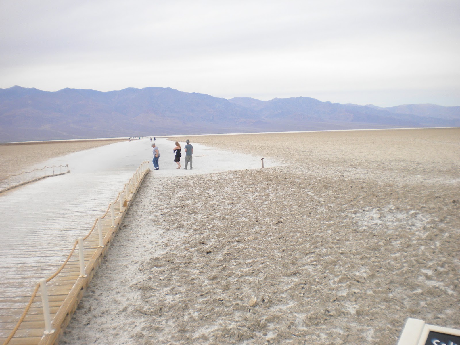
After they got over the mountains and down into the Valley, this is one of the views they saw. These are the salt flats that were left behind when a huge lake dried up many, many years ago.

After driving for many miles, they came to Badwater Basin, the lowest point in elevation in North America, and 282' below sea level.
 This next photo is looking out over Badwater Basin

If you click on this next photo, you'll see a sign way up there on the side of the mountain. The sign says "Sea Level"..

From Badwater, they continued on towards the Furnace Creek and saw some more interesting sights along the way. One road they went on was called "Artist Drive".

This is a 1 lane one-way road leading back into the mountains and it is restricted to vehicles of less than 25' CLT says that there was a small Motor Home on the road and he was having difficulties maneuvering through the narrow passages between the rocks.
About half way through the nine mile drive, there's an area called "Artist Palette", which CLT says is really neat. You can't see it too well in the photos below, but the different sections of the rock are different colors. Some red, blue, green, and of course many shades of brown.
 I think if the sun would have been shinning when Jim took these pictures, the colors would have stood out more.

A little after Artist Drive, they came to Furnace Creek where they turned right and headed back here to the Park. It was about about 2:00 by the time they got back and poor little CLT had traveled about 150 miles, much of it up and down mountains!!!
No wonder CLT was dragging his tail gate by the time he returned!!!! ; O
All in all, both Jim and Linda said it was a great day. They really enjoyed the scenery and are glad they went back to see the valley from the bottom. Death Valley is a great place to visit and you can probably spend many days seeing everything there is to see in the park. Be advised though, during the summer months, it's not uncommon for the temperatures to get well over 100 degrees.
Most seem to agree, that the spring or fall are the ideal times to visit. Today for instance, the temperature down in the valley was about 75 to 80 degrees.
Just right for a nice drive through the park. : )
Did you know that the record high temperature in Death Valley is 134 degrees, set in July of 1913?
48 deg. clear, no wind.
Forecast = Partly cloudy. High of 79F. Winds less than 5 mph.
Poor little CLT! He really had a busy day yesterday and by the time he returned here to the RV Park in Tecopa, his little tail gate was almost dragging the ground!!!! ; )
"Why was that?" you ask.
Well, Jim and Linda decided to head back to Death Valley and this time, go to the bottom of the valley to see it, instead of looking at it from above, and CLT had to get them there. So, , , , , , about 9:45 they hopped into CLT and took off.
Now to get to the bottom of Death Valley, you first have to go up and over some mountains to get down into the valley, and that's what almost did poor CLT in. We're at about 1300' here at the RV Park and the mountains that you have to cross are over 3000'. And, as most of you know, Death Valley is quite a ways below sea level. : (
So, off they went.
Just past Shoshone, they turned off of Route 127 onto Rt 178 and followed it West.


This is a 1 lane one-way road leading back into the mountains and it is restricted to vehicles of less than 25' CLT says that there was a small Motor Home on the road and he was having difficulties maneuvering through the narrow passages between the rocks.
About half way through the nine mile drive, there's an area called "Artist Palette", which CLT says is really neat. You can't see it too well in the photos below, but the different sections of the rock are different colors. Some red, blue, green, and of course many shades of brown.


No wonder CLT was dragging his tail gate by the time he returned!!!! ; O
All in all, both Jim and Linda said it was a great day. They really enjoyed the scenery and are glad they went back to see the valley from the bottom. Death Valley is a great place to visit and you can probably spend many days seeing everything there is to see in the park. Be advised though, during the summer months, it's not uncommon for the temperatures to get well over 100 degrees.
Most seem to agree, that the spring or fall are the ideal times to visit. Today for instance, the temperature down in the valley was about 75 to 80 degrees.
Just right for a nice drive through the park. : )
Did you know that the record high temperature in Death Valley is 134 degrees, set in July of 1913?
Sunday, March 25, 2012
First Trip Into Death Valley
Tecopa, CA.
46 deg. clear, no wind.
Forecast = Partly cloudy in the morning, then mostly cloudy with a chance of rain. High of 66F. Winds from the East at 5 to 15 mph with gusts to 30 mph. Chance of rain 40%.
After starting the day with a sunrise like this, Jim just knew it had to be a good day for exploring parts of Death Valley. : )
 So, after packing some things to take along, (a water jug filled with ice water, some snacks and a lunch for Linda), they headed towards the valley.
The road getting to Death Valley is in very good condition and there's lots of pull-off places where you can stop to take photos or have a drink of that nice cool water that you brought along.
 This is one of the first markers they came to. If you click on this photo, or any of the others, they will enlarge.
 The above marker was just a little ways before they came to the Furnace Creek Visitor Center where they went inside and looked at some of the exhibits and got maps and brochures about Death Valley from the park rangers.
 After having some lunch and studying the maps and brochures, it was decided that they would check out something that Jim had read and heard about.
They had decided to go to the area known as Dantes View!!!
From the Visitors Center, they came back the way they had come until they came to the sign pointing to Dantes View. As soon as they turned off of the main road, there was a sign saying that the last 1/4 mile of this 13 mile road had a 17% grade!!!!!!
Yep, you read that right. 17%!!!!!!!
CLT said that the road was in good condition, but there were lots of twists and curves and he was gaining altitude all the way. About 2/3 of the way there, there was a sign saying that no trailers were allowed further down the road and that there was a parking place for them if you wanted to continue.
Past that point, CLT says the road became more twisty with some hair-pin turns and the grade got steeper. And, true to that first sign, the last 1/4 mile was at a 17% grade!!!!
CLT said that at times he felt like he was going straight up!!! He said that Jim had to put his transmission way down into 1st gear to get up to the top!!!
 But, he made it, and Oh Boy!!!! What a view he had when he got there!!!!
Dantes View is at 5475' above sea level and the bottom of the valley that you see in the photos is 282' below sea level.

 CLT says that the above photos don't really show the depth of the valley or the beautiful shades of color, but I'm hoping you can get an idea of what it was like. It's like many places, you can't really see or know what it's like unless you go there and experience it for yourself.
Then, after taking in the view, it was time to start heading back down. The photo below shows only a small portion of the road, but maybe you can get an idea of what it was like. CLT said that the speed limit going down on the first steep section of road was 10 MPH and he said the definitely wouldn't have wanted to go any faster than that. : O
 It was about 3:00 by the time Jim, Linda and CLT returned here to the park. Jim and Linda were both talking about how great the day was and how much they enjoyed it.
After relaxing a bit, they both took naps. ; )
As for CLT, I think he was just plain tired from doing all that climbing. I didn't hear a thing from him until later in the evening. ; )
Did you know that Mt. Whitney at 14,491 feet above sea level, (the highest point in the lower 48 states), and Death Valley at 282 feet below sea level, (the lowest point in the lower 48 states), are only about 100 miles apart?
46 deg. clear, no wind.
Forecast = Partly cloudy in the morning, then mostly cloudy with a chance of rain. High of 66F. Winds from the East at 5 to 15 mph with gusts to 30 mph. Chance of rain 40%.
After starting the day with a sunrise like this, Jim just knew it had to be a good day for exploring parts of Death Valley. : )

The road getting to Death Valley is in very good condition and there's lots of pull-off places where you can stop to take photos or have a drink of that nice cool water that you brought along.


They had decided to go to the area known as Dantes View!!!
From the Visitors Center, they came back the way they had come until they came to the sign pointing to Dantes View. As soon as they turned off of the main road, there was a sign saying that the last 1/4 mile of this 13 mile road had a 17% grade!!!!!!
Yep, you read that right. 17%!!!!!!!
CLT said that the road was in good condition, but there were lots of twists and curves and he was gaining altitude all the way. About 2/3 of the way there, there was a sign saying that no trailers were allowed further down the road and that there was a parking place for them if you wanted to continue.
Past that point, CLT says the road became more twisty with some hair-pin turns and the grade got steeper. And, true to that first sign, the last 1/4 mile was at a 17% grade!!!!
CLT said that at times he felt like he was going straight up!!! He said that Jim had to put his transmission way down into 1st gear to get up to the top!!!

Dantes View is at 5475' above sea level and the bottom of the valley that you see in the photos is 282' below sea level.


Then, after taking in the view, it was time to start heading back down. The photo below shows only a small portion of the road, but maybe you can get an idea of what it was like. CLT said that the speed limit going down on the first steep section of road was 10 MPH and he said the definitely wouldn't have wanted to go any faster than that. : O

After relaxing a bit, they both took naps. ; )
As for CLT, I think he was just plain tired from doing all that climbing. I didn't hear a thing from him until later in the evening. ; )
Did you know that Mt. Whitney at 14,491 feet above sea level, (the highest point in the lower 48 states), and Death Valley at 282 feet below sea level, (the lowest point in the lower 48 states), are only about 100 miles apart?
Saturday, March 24, 2012
Out Of Nevada And Back Into California
54 Deg. clear, NE wind @ 5 mph.
Forecast = Partly cloudy. High of 75F. Winds from the ESE at 5 to 15 mph with gusts to 30 mph
Because they were forecasting some possible windy conditions later on in the day, we left the Cal-Nev-Ari RV Park earlier than usual, (about ), and continued North on US95.
When we came to the town of Searchlight
 It’s kind of like riding a roller-coaster and it’s necessary to give full attention to the driving. Once we crossed into
 California Nipton
Yes, up into those mountains in the photo above. ; )

Yes, up into those mountains in the photo above. ; )
Turning West on 15, it was still more climbing for another 15 miles or so, before we started going down again, all the way to Baker.
Once to Baker, we turned North on CA127,
 and brought it up to the Old Spanish Trail Road, which took us into Tecopa and the Petersen’s Tecopa Palms RV Park, where Jim had made reservations for me.


CA127 is a very good road with very smooth pavement, but again it had lots of humps and dips and was very curvy and hilly in places.
It was 1 when we pulled into the park, so it took us about 2 hours and 50 minutes to travel 133 miles. Not too bad considering we slowed down for the dips and humps on the roads.
Petersen’s Tecopa Palms RV Park is a very well maintained park, and the owners are supper friendly and willing to help in any way they can. I’ve got one of the longer sites in the park and in fact, there’s a whole vacant area behind me.

I’ve got full hook-ups with 50 amp electric and a great view of the mountains off to my right, left, front and rear. ; )


I’ve got full hook-ups with 50 amp electric and a great view of the mountains off to my right, left, front and rear. ; )

I think I’m going to like it here for the next week. : )
A Point to Ponder : Character consists of what you do on the third and fourth tries.
Subscribe to:
Posts (Atom)