Rantoul, IL.
53 deg. clear, NW wind @ 7 mph.
Forecast = Mostly sunny. Highs around 80. Northwest winds 5 to 10 mph.
Wow!!! 53 degrees this morning!!!!
Because we're so used to it being so hot for so long in this part of the country, 53 degrees feels like it's winter!!!! Wouldn't it be nice if the temperatures didn't go from one extreme to the other so often?
I received a few comments on yesterday's blog about how far we have traveled and how many states we have been to in during the last 13 months. Yes, we did travel a lot this year, and I really don't expect to be traveling anywhere near that much every year.
The thing was, it had been 4 years since Jim and Linda had been out west to see Jeff and Heather who live in Portland Oregon, and, since you're going that far anyway, it would be a shame not to see other attractions or areas along the way, even if you had to take a longer route to see them.
Yeah, we could have gone straight out to Portland from Florida, and then straight back here to Illinois, and probably reduced the distance by 3 or 4 thousand miles, but just think of all the wonderful sights we would have missed. Things like the beautiful sunsets in the desert of Arizona, the stark beauty of Death Valley, the majesty of the Sequoias and the Redwoods, the beautiful California and Oregon coasts, the beauty of the mountains in northern Idaho and the "Big Skies" of Montana. We wouldn't have seen the wheat fields of the Dakotas or the lakes and forests of Minnesota. And, don't forget that great week we spent on the Keweenaw Peninsula in Michigan where we saw some of the most beautiful sunsets, over Lake Superior, I've ever seen.
No, I wouldn't want to take such a long trip every year, but in a few years, I'll be ready to go again. ; ) Maybe next time we can visit Mt. Rushmore, Devil's Tower, the Great Salt Lake, some of the National Parks in Utah and Wyoming, and maybe even the coast of Washington!!!!
Hmmm!!!! Where's that Road Atlas????? ; )
Did you know that the five Olympic rings represent the five major regions of the world – Africa, the Americas, Asia, Europe and Oceana, and are interconnected to symbolize the friendship to be gained from these international competitions? The colors were chosen because at least one of them appeared on the flag of every country in the world.
Showing posts with label scenery. Show all posts
Showing posts with label scenery. Show all posts
Saturday, August 11, 2012

Wednesday, May 2, 2012
Wandering Into Oregon
Florence, OR.
42 deg. overcast, no wind.
Forecast = Overcast with a chance of rain, then rain in the afternoon. High of 63F. Winds from the SSW at 5 to 10 mph.
We left Crescent City about 9:45 and continued North on US 101. The road from Crescent City up to Bandon, Or. leaves something to be desired as it's bumpy, curvy and there's quite a few areas where construction is in progress. Many areas have had landslides where the road has slid down the hills and has been repaired, or is being repaired. All of these areas are rough and in places we were down below 30 mph.
Once past Bandon, the road is in much better condition. Oh, there are a few rough spots but for the most part we moved right along.
All along the Oregon coast there were great views of the ocean. Jim was able to get a few photos, but none of them are too great.


It was 2:00 when we pulled into the Pacific Pines RV Park here in Florence. That meant that we traveled 178 miles in 4 hours and 15 minutes. Really not too bad considering the road.
This is a nice park with full hook-ups, 50 amp electric, free cable TV, free wi-fi, level cement pull-thru and back-in sites, and nicely landscaped with flowering bushes and plants between the sites.
 The sites are fairly close together though, and the sites are plenty long for me, but Jim had to un-hook CLT.
 The lady in the office was very nice and made sure Jim knew where the laundry, bathrooms and other amenities were located. She also made sure that Jim knew the best way to get me to my site.
After getting me into my site and set up, Jim took a little nap. Then, about 5:30, he and Linda took CLT and went into town and to Mo's Seafood Restaurant for dinner.
Mo's is pretty famous in Oregon. Their main claim to fame is their clam chowder, which has even been served in the White House.
 The lady at the RV Park gave Jim 2 tokens for a free cup of clam chowder and coupons for 2 free non-alcoholic beverages, so they both had the clam chowder. Jim also had crab cakes and Linda had clam strips. That along with their free beverage made for a nice meal.
 While they were eating, they were able to enjoy the great view of the Siuslaw River out of the window by their table.

42 deg. overcast, no wind.
Forecast = Overcast with a chance of rain, then rain in the afternoon. High of 63F. Winds from the SSW at 5 to 10 mph.
We left Crescent City about 9:45 and continued North on US 101. The road from Crescent City up to Bandon, Or. leaves something to be desired as it's bumpy, curvy and there's quite a few areas where construction is in progress. Many areas have had landslides where the road has slid down the hills and has been repaired, or is being repaired. All of these areas are rough and in places we were down below 30 mph.
Once past Bandon, the road is in much better condition. Oh, there are a few rough spots but for the most part we moved right along.
All along the Oregon coast there were great views of the ocean. Jim was able to get a few photos, but none of them are too great.


It was 2:00 when we pulled into the Pacific Pines RV Park here in Florence. That meant that we traveled 178 miles in 4 hours and 15 minutes. Really not too bad considering the road.
This is a nice park with full hook-ups, 50 amp electric, free cable TV, free wi-fi, level cement pull-thru and back-in sites, and nicely landscaped with flowering bushes and plants between the sites.


After getting me into my site and set up, Jim took a little nap. Then, about 5:30, he and Linda took CLT and went into town and to Mo's Seafood Restaurant for dinner.
Mo's is pretty famous in Oregon. Their main claim to fame is their clam chowder, which has even been served in the White House.


Linda's clam strips were very good, but Jim's crab cakes were spicy and he didn't much like them. As for the clam chowder, Jim said that he liked the clam chowder that he had in Crescent City better than this. Linda however, thought the chowder was excellent.
Today, we'll continue wandering up the coast. I don't know how far we'll get. On the map, it looks like it's going to be pretty twisty-turny.
Did you know that The Oregon Coast stretches approximately 363 miles from the Columbia River in the north to the Oregon–California state border in the south?
Sunday, April 29, 2012
I Forgot, An Un-Dissapointment and Craby
Crescent City, CA.
45 deg. clear, no wind
Forecast = Partly cloudy in the morning, then mostly cloudy. High of 57F. Breezy. Winds from the NNW at 15 to 20 mph. Chance of rain 40%
Boy!!!! Did I ever blow it yesterday. I forgot one of the highlights of the day!!! OK, it may not be real exciting, but Jim and Linda really enjoyed it.
When Jim paid for 3 more nights here at the Shoreline RV Park and Campground he asked the CG host if there was a restaurant in the area that he would recommend. Without hesitation, he said "The Chart Room Restaurant" . So, about 5:00 they headed over there to see of they could get some Seafood for dinner.
Well, as far as Jim and Linda are concerned, it was great!!!! Jim had a coup of clam chowder and then their "Famous Fish-N-Chips" and Linda had the Shrimp and Chips. They both thought the food was excellent, the service was very good and the view out over the bay was super!!!
As you can probably tell, they really liked it!!! ; )
Oh, and the sea lions over by the restaurant liked the dock too!! : )

Now, for yesterday's activities.
It was sometime in the morning when Jim was outside that he talked to Ed, (My neighbor who's RV you saw in yesterday's post), and mentioned that they tried to take that scenic drive through the Jedediah Smith State Park, but couldn't because the road was closed. Well, Ed said that he and his wife had just been to the other end of the road and it was open far enough that you could go at least as far as Stout Grove, and that's where most of the biggest trees are at.
So , , , , ,after grabbing an early bite to eat for lunch, they took CLT and headed to the other end of the scenic road and enter the Redwood forest from there!!! : )
 The photos below are of the 1 lane gravel road running through the forest. CLT says that there are a lot of wide spots where you can pass another vehicle, should you meet one.
 The photo below shows how large the trees actually are. That's a full-sized SUV coming toward you.
 CLT waiting in a parking area while Jim took a few photos.
 Photos, like this neat mountain stream.
 The Smith River also runs through the park, and CLT says, "Yes, the water really is that color"!!
 It was around 2:00 by the time CLT brought them back here to the CG, and from what I overheard, they really enjoyed their excursion. : )
Oh, one more thing. During the day yesterday, the man from the RV, (kind of behind me), knocked on my door and brought Jim and Linda 4 nice sized crabs that he had caught with his crab nets. Jim had been talking to him the other day, and he had asked Jim if he and Linda liked crab? Well to make a long story shorter, yesterday he went out crabbing and caught a whole bunch, so he brought some over here. All cleaned and everything!!!
Wasn't that nice of him?
Linda had never cooked crab before, but the man told her how to do it. So for dinner, Jim and Linda had crab!!! Both of them really enjoyed it and today, Jim will be going over there to return the man's pot and thank him again for giving them the crabs.
You meet the nicest people in Campgrounds and RV Parks!!!! ; )
Did you know that the Coast Redwood Tree grows from a seed that is about the size of a tomato seed?
45 deg. clear, no wind
Forecast = Partly cloudy in the morning, then mostly cloudy. High of 57F. Breezy. Winds from the NNW at 15 to 20 mph. Chance of rain 40%
Boy!!!! Did I ever blow it yesterday. I forgot one of the highlights of the day!!! OK, it may not be real exciting, but Jim and Linda really enjoyed it.
When Jim paid for 3 more nights here at the Shoreline RV Park and Campground he asked the CG host if there was a restaurant in the area that he would recommend. Without hesitation, he said "The Chart Room Restaurant" . So, about 5:00 they headed over there to see of they could get some Seafood for dinner.
Well, as far as Jim and Linda are concerned, it was great!!!! Jim had a coup of clam chowder and then their "Famous Fish-N-Chips" and Linda had the Shrimp and Chips. They both thought the food was excellent, the service was very good and the view out over the bay was super!!!
As you can probably tell, they really liked it!!! ; )
Oh, and the sea lions over by the restaurant liked the dock too!! : )

Now, for yesterday's activities.
It was sometime in the morning when Jim was outside that he talked to Ed, (My neighbor who's RV you saw in yesterday's post), and mentioned that they tried to take that scenic drive through the Jedediah Smith State Park, but couldn't because the road was closed. Well, Ed said that he and his wife had just been to the other end of the road and it was open far enough that you could go at least as far as Stout Grove, and that's where most of the biggest trees are at.
So , , , , ,after grabbing an early bite to eat for lunch, they took CLT and headed to the other end of the scenic road and enter the Redwood forest from there!!! : )


Oh, one more thing. During the day yesterday, the man from the RV, (kind of behind me), knocked on my door and brought Jim and Linda 4 nice sized crabs that he had caught with his crab nets. Jim had been talking to him the other day, and he had asked Jim if he and Linda liked crab? Well to make a long story shorter, yesterday he went out crabbing and caught a whole bunch, so he brought some over here. All cleaned and everything!!!
Wasn't that nice of him?
Linda had never cooked crab before, but the man told her how to do it. So for dinner, Jim and Linda had crab!!! Both of them really enjoyed it and today, Jim will be going over there to return the man's pot and thank him again for giving them the crabs.
You meet the nicest people in Campgrounds and RV Parks!!!! ; )
Did you know that the Coast Redwood Tree grows from a seed that is about the size of a tomato seed?
Thursday, March 29, 2012
Poor Little CLT
Tecopa, CA.
48 deg. clear, no wind.
Forecast = Partly cloudy. High of 79F. Winds less than 5 mph.
Poor little CLT! He really had a busy day yesterday and by the time he returned here to the RV Park in Tecopa, his little tail gate was almost dragging the ground!!!! ; )
"Why was that?" you ask.
Well, Jim and Linda decided to head back to Death Valley and this time, go to the bottom of the valley to see it, instead of looking at it from above, and CLT had to get them there. So, , , , , , about 9:45 they hopped into CLT and took off.
Now to get to the bottom of Death Valley, you first have to go up and over some mountains to get down into the valley, and that's what almost did poor CLT in. We're at about 1300' here at the RV Park and the mountains that you have to cross are over 3000'. And, as most of you know, Death Valley is quite a ways below sea level. : (
So, off they went.
Just past Shoshone, they turned off of Route 127 onto Rt 178 and followed it West.

A ways down the road, 178 ended and it became Badwater Road as they entered Death Valley N.P.

CLT said that it was very scenic, but the road just kept going up and down and it took all he could do to get over some of the higher mountains.

Some distance into the Park, they came to the Ashford Mill Ruins. If you click on the photo below, it will enlarge, and you'll be able to read all about it.

This is all that's left of the Mill.

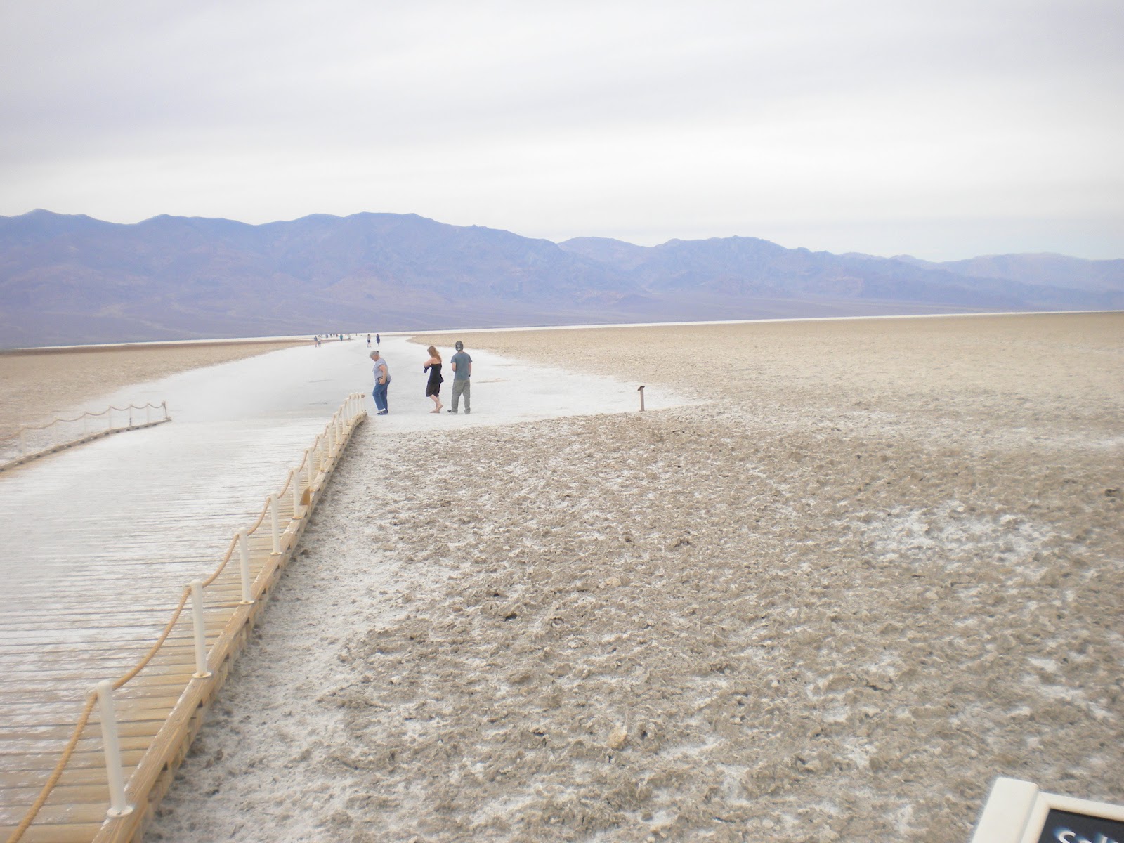
After they got over the mountains and down into the Valley, this is one of the views they saw. These are the salt flats that were left behind when a huge lake dried up many, many years ago.

After driving for many miles, they came to Badwater Basin, the lowest point in elevation in North America, and 282' below sea level.
 This next photo is looking out over Badwater Basin

If you click on this next photo, you'll see a sign way up there on the side of the mountain. The sign says "Sea Level"..

From Badwater, they continued on towards the Furnace Creek and saw some more interesting sights along the way. One road they went on was called "Artist Drive".

This is a 1 lane one-way road leading back into the mountains and it is restricted to vehicles of less than 25' CLT says that there was a small Motor Home on the road and he was having difficulties maneuvering through the narrow passages between the rocks.
About half way through the nine mile drive, there's an area called "Artist Palette", which CLT says is really neat. You can't see it too well in the photos below, but the different sections of the rock are different colors. Some red, blue, green, and of course many shades of brown.
 I think if the sun would have been shinning when Jim took these pictures, the colors would have stood out more.

A little after Artist Drive, they came to Furnace Creek where they turned right and headed back here to the Park. It was about about 2:00 by the time they got back and poor little CLT had traveled about 150 miles, much of it up and down mountains!!!
No wonder CLT was dragging his tail gate by the time he returned!!!! ; O
All in all, both Jim and Linda said it was a great day. They really enjoyed the scenery and are glad they went back to see the valley from the bottom. Death Valley is a great place to visit and you can probably spend many days seeing everything there is to see in the park. Be advised though, during the summer months, it's not uncommon for the temperatures to get well over 100 degrees.
Most seem to agree, that the spring or fall are the ideal times to visit. Today for instance, the temperature down in the valley was about 75 to 80 degrees.
Just right for a nice drive through the park. : )
Did you know that the record high temperature in Death Valley is 134 degrees, set in July of 1913?
48 deg. clear, no wind.
Forecast = Partly cloudy. High of 79F. Winds less than 5 mph.
Poor little CLT! He really had a busy day yesterday and by the time he returned here to the RV Park in Tecopa, his little tail gate was almost dragging the ground!!!! ; )
"Why was that?" you ask.
Well, Jim and Linda decided to head back to Death Valley and this time, go to the bottom of the valley to see it, instead of looking at it from above, and CLT had to get them there. So, , , , , , about 9:45 they hopped into CLT and took off.
Now to get to the bottom of Death Valley, you first have to go up and over some mountains to get down into the valley, and that's what almost did poor CLT in. We're at about 1300' here at the RV Park and the mountains that you have to cross are over 3000'. And, as most of you know, Death Valley is quite a ways below sea level. : (
So, off they went.
Just past Shoshone, they turned off of Route 127 onto Rt 178 and followed it West.




This is a 1 lane one-way road leading back into the mountains and it is restricted to vehicles of less than 25' CLT says that there was a small Motor Home on the road and he was having difficulties maneuvering through the narrow passages between the rocks.
About half way through the nine mile drive, there's an area called "Artist Palette", which CLT says is really neat. You can't see it too well in the photos below, but the different sections of the rock are different colors. Some red, blue, green, and of course many shades of brown.


No wonder CLT was dragging his tail gate by the time he returned!!!! ; O
All in all, both Jim and Linda said it was a great day. They really enjoyed the scenery and are glad they went back to see the valley from the bottom. Death Valley is a great place to visit and you can probably spend many days seeing everything there is to see in the park. Be advised though, during the summer months, it's not uncommon for the temperatures to get well over 100 degrees.
Most seem to agree, that the spring or fall are the ideal times to visit. Today for instance, the temperature down in the valley was about 75 to 80 degrees.
Just right for a nice drive through the park. : )
Did you know that the record high temperature in Death Valley is 134 degrees, set in July of 1913?
Sunday, March 25, 2012
First Trip Into Death Valley
Tecopa, CA.
46 deg. clear, no wind.
Forecast = Partly cloudy in the morning, then mostly cloudy with a chance of rain. High of 66F. Winds from the East at 5 to 15 mph with gusts to 30 mph. Chance of rain 40%.
After starting the day with a sunrise like this, Jim just knew it had to be a good day for exploring parts of Death Valley. : )
 So, after packing some things to take along, (a water jug filled with ice water, some snacks and a lunch for Linda), they headed towards the valley.
The road getting to Death Valley is in very good condition and there's lots of pull-off places where you can stop to take photos or have a drink of that nice cool water that you brought along.
 This is one of the first markers they came to. If you click on this photo, or any of the others, they will enlarge.
 The above marker was just a little ways before they came to the Furnace Creek Visitor Center where they went inside and looked at some of the exhibits and got maps and brochures about Death Valley from the park rangers.
 After having some lunch and studying the maps and brochures, it was decided that they would check out something that Jim had read and heard about.
They had decided to go to the area known as Dantes View!!!
From the Visitors Center, they came back the way they had come until they came to the sign pointing to Dantes View. As soon as they turned off of the main road, there was a sign saying that the last 1/4 mile of this 13 mile road had a 17% grade!!!!!!
Yep, you read that right. 17%!!!!!!!
CLT said that the road was in good condition, but there were lots of twists and curves and he was gaining altitude all the way. About 2/3 of the way there, there was a sign saying that no trailers were allowed further down the road and that there was a parking place for them if you wanted to continue.
Past that point, CLT says the road became more twisty with some hair-pin turns and the grade got steeper. And, true to that first sign, the last 1/4 mile was at a 17% grade!!!!
CLT said that at times he felt like he was going straight up!!! He said that Jim had to put his transmission way down into 1st gear to get up to the top!!!
 But, he made it, and Oh Boy!!!! What a view he had when he got there!!!!
Dantes View is at 5475' above sea level and the bottom of the valley that you see in the photos is 282' below sea level.

 CLT says that the above photos don't really show the depth of the valley or the beautiful shades of color, but I'm hoping you can get an idea of what it was like. It's like many places, you can't really see or know what it's like unless you go there and experience it for yourself.
Then, after taking in the view, it was time to start heading back down. The photo below shows only a small portion of the road, but maybe you can get an idea of what it was like. CLT said that the speed limit going down on the first steep section of road was 10 MPH and he said the definitely wouldn't have wanted to go any faster than that. : O
 It was about 3:00 by the time Jim, Linda and CLT returned here to the park. Jim and Linda were both talking about how great the day was and how much they enjoyed it.
After relaxing a bit, they both took naps. ; )
As for CLT, I think he was just plain tired from doing all that climbing. I didn't hear a thing from him until later in the evening. ; )
Did you know that Mt. Whitney at 14,491 feet above sea level, (the highest point in the lower 48 states), and Death Valley at 282 feet below sea level, (the lowest point in the lower 48 states), are only about 100 miles apart?
46 deg. clear, no wind.
Forecast = Partly cloudy in the morning, then mostly cloudy with a chance of rain. High of 66F. Winds from the East at 5 to 15 mph with gusts to 30 mph. Chance of rain 40%.
After starting the day with a sunrise like this, Jim just knew it had to be a good day for exploring parts of Death Valley. : )

The road getting to Death Valley is in very good condition and there's lots of pull-off places where you can stop to take photos or have a drink of that nice cool water that you brought along.


They had decided to go to the area known as Dantes View!!!
From the Visitors Center, they came back the way they had come until they came to the sign pointing to Dantes View. As soon as they turned off of the main road, there was a sign saying that the last 1/4 mile of this 13 mile road had a 17% grade!!!!!!
Yep, you read that right. 17%!!!!!!!
CLT said that the road was in good condition, but there were lots of twists and curves and he was gaining altitude all the way. About 2/3 of the way there, there was a sign saying that no trailers were allowed further down the road and that there was a parking place for them if you wanted to continue.
Past that point, CLT says the road became more twisty with some hair-pin turns and the grade got steeper. And, true to that first sign, the last 1/4 mile was at a 17% grade!!!!
CLT said that at times he felt like he was going straight up!!! He said that Jim had to put his transmission way down into 1st gear to get up to the top!!!

Dantes View is at 5475' above sea level and the bottom of the valley that you see in the photos is 282' below sea level.


Then, after taking in the view, it was time to start heading back down. The photo below shows only a small portion of the road, but maybe you can get an idea of what it was like. CLT said that the speed limit going down on the first steep section of road was 10 MPH and he said the definitely wouldn't have wanted to go any faster than that. : O

After relaxing a bit, they both took naps. ; )
As for CLT, I think he was just plain tired from doing all that climbing. I didn't hear a thing from him until later in the evening. ; )
Did you know that Mt. Whitney at 14,491 feet above sea level, (the highest point in the lower 48 states), and Death Valley at 282 feet below sea level, (the lowest point in the lower 48 states), are only about 100 miles apart?
Saturday, March 24, 2012
Out Of Nevada And Back Into California
54 Deg. clear, NE wind @ 5 mph.
Forecast = Partly cloudy. High of 75F. Winds from the ESE at 5 to 15 mph with gusts to 30 mph
Because they were forecasting some possible windy conditions later on in the day, we left the Cal-Nev-Ari RV Park earlier than usual, (about ), and continued North on US95.
When we came to the town of Searchlight
 It’s kind of like riding a roller-coaster and it’s necessary to give full attention to the driving. Once we crossed into
 California Nipton
Yes, up into those mountains in the photo above. ; )

Yes, up into those mountains in the photo above. ; )
Turning West on 15, it was still more climbing for another 15 miles or so, before we started going down again, all the way to Baker.
Once to Baker, we turned North on CA127,
 and brought it up to the Old Spanish Trail Road, which took us into Tecopa and the Petersen’s Tecopa Palms RV Park, where Jim had made reservations for me.


CA127 is a very good road with very smooth pavement, but again it had lots of humps and dips and was very curvy and hilly in places.
It was 1 when we pulled into the park, so it took us about 2 hours and 50 minutes to travel 133 miles. Not too bad considering we slowed down for the dips and humps on the roads.
Petersen’s Tecopa Palms RV Park is a very well maintained park, and the owners are supper friendly and willing to help in any way they can. I’ve got one of the longer sites in the park and in fact, there’s a whole vacant area behind me.

I’ve got full hook-ups with 50 amp electric and a great view of the mountains off to my right, left, front and rear. ; )


I’ve got full hook-ups with 50 amp electric and a great view of the mountains off to my right, left, front and rear. ; )

I think I’m going to like it here for the next week. : )
A Point to Ponder : Character consists of what you do on the third and fourth tries.
Thursday, March 15, 2012
The Dream Catcher RV Park
Deming, NM
35 deg. clear, no wind.
Forecast = Clear in the morning, then overcast. High of 77F. Winds from the NNW at 5 to 10 mph shifting to the ESE in the afternoon.
Jim and Linda took CLT and headed to a Grocery store yesterday morning. They didn't need much, but were out of a few essentials. After lunch, Linda put a load of laundry in my washer/dryer while Jim fooled around outside and took a few photos of the park and the surrounding area.
Jim and Linda like this Escapees RV Club park. It's nothing special as far as parks go, but there's a friendly bunch of people here and they've always enjoyed being here.
This first photo is of the entrance to the park.

As soon as you turn into the park you come to the Office/Clubhouse. Jim and Linda said that when they first came here, it was much smaller than it is now.

This is a view of the CG as you leave the Office. Most of the sites are pull-through with full hook-ups. As you can see there weren't a real lot of RVs here when Jim took the photo, but it's getting late in the season for people to be staying for long stretches and actually by late afternoon, there's quite a few more here.

This last photo was taken looking kind of SE from the park in the evening. It was kind of hazy when Jim took this, but I liked the way the setting sun was creating shadows on the mountain.

Today will be our last day here. We were originally going to stay a week, but because of my fuel system problem, our time here will have to be cut short. I don't know if there's anything planned for today. I do know that they're having a potluck dinner over at the clubhouse tonight that Jim and Linda are signed up for.
I guess I'll just have to wait and see what happens. ; )
Did you know that while St. Patrick's Day has been a religious observance in Ireland for years and it wasn't until 1995 that the Irish Government decided to "cut loose" and really promote the holiday on a global level? In fact, from 1903 until the 1970s, pubs were closed in Ireland on March 17th!
35 deg. clear, no wind.
Forecast = Clear in the morning, then overcast. High of 77F. Winds from the NNW at 5 to 10 mph shifting to the ESE in the afternoon.
Jim and Linda took CLT and headed to a Grocery store yesterday morning. They didn't need much, but were out of a few essentials. After lunch, Linda put a load of laundry in my washer/dryer while Jim fooled around outside and took a few photos of the park and the surrounding area.
Jim and Linda like this Escapees RV Club park. It's nothing special as far as parks go, but there's a friendly bunch of people here and they've always enjoyed being here.
This first photo is of the entrance to the park.


This is a view of the CG as you leave the Office. Most of the sites are pull-through with full hook-ups. As you can see there weren't a real lot of RVs here when Jim took the photo, but it's getting late in the season for people to be staying for long stretches and actually by late afternoon, there's quite a few more here.

This last photo was taken looking kind of SE from the park in the evening. It was kind of hazy when Jim took this, but I liked the way the setting sun was creating shadows on the mountain.

Today will be our last day here. We were originally going to stay a week, but because of my fuel system problem, our time here will have to be cut short. I don't know if there's anything planned for today. I do know that they're having a potluck dinner over at the clubhouse tonight that Jim and Linda are signed up for.
I guess I'll just have to wait and see what happens. ; )
Did you know that while St. Patrick's Day has been a religious observance in Ireland for years and it wasn't until 1995 that the Irish Government decided to "cut loose" and really promote the holiday on a global level? In fact, from 1903 until the 1970s, pubs were closed in Ireland on March 17th!
Sunday, March 11, 2012
Did You Remember? and More Catching Up
Van Horn, TX.
29 Deg. clear, SW wind @ 8 mph.
Forecast = Clear. High of 66F. Winds from the WNW at 15-25 mph
Did you remember to turn all of your clocks ahead 1 hour?
Nothing much happened around here yesterday, so I thought I'd get caught up on some photos. This first one is the view you see of the Ft. Stockton, RV Park in Fort Stockton, TX.
 As you're driving into the park on the above road and you look off to the right, this is what you see.
 A little further down the road, you make a right turn and come to the office. As you can probably tell by the building, it used to be a KOA park
 In the photo below, you see me in my site and the native plants that I talked about the other day.
 Like I said, Jim and Linda like this park. You have to remember that this park in in a desert type climate, so you don't have big trees or lots of green grass.
In this next photo, you can get an idea of the dust that was blowing around as we pulled into the Eagle's Nest RV Park here in Van Horn. These hills/mountains, are just a short distance from the park and it was so dusty, it almost looked like fog. : (
 The office
 The pull-through sites.
 From the office, if you turn to the right and go all the way to the last row, you will find that these sites are longer and can accommodate very large RVs. My site is plenty long enough to leave CLT hooked up behind me and still have the utilities located about 1/2 way down my left site.
I pretty sure that to many people these RV Parks seem barren without much vegetation, but you have to remember, many things do not grow here, and if they do, they're many times smaller than you might expect. It's very dry in this area, so cactus and small trees are the norm, and the dryness, also means there's lots of dust to blow around when it gets windy.
To me, there's a different kind of beauty to the landscape. If you just drive by and just see rocks and cactus, you're missing a lot. Look at the rock formations, the different kinds of cactus, the layers of rock and dirt that make up the hills and mountains. And don't forget to watch for all different kinds of wildlife.
You may be surprised at what you see if you look. ; )
Did you know that the annual precipitation for Van Horn, TX. is only 12"? The annual precipitation for Columbus OH, is 40".
29 Deg. clear, SW wind @ 8 mph.
Forecast = Clear. High of 66F. Winds from the WNW at 15-25 mph
Did you remember to turn all of your clocks ahead 1 hour?
Nothing much happened around here yesterday, so I thought I'd get caught up on some photos. This first one is the view you see of the Ft. Stockton, RV Park in Fort Stockton, TX.


In this next photo, you can get an idea of the dust that was blowing around as we pulled into the Eagle's Nest RV Park here in Van Horn. These hills/mountains, are just a short distance from the park and it was so dusty, it almost looked like fog. : (


I pretty sure that to many people these RV Parks seem barren without much vegetation, but you have to remember, many things do not grow here, and if they do, they're many times smaller than you might expect. It's very dry in this area, so cactus and small trees are the norm, and the dryness, also means there's lots of dust to blow around when it gets windy.
To me, there's a different kind of beauty to the landscape. If you just drive by and just see rocks and cactus, you're missing a lot. Look at the rock formations, the different kinds of cactus, the layers of rock and dirt that make up the hills and mountains. And don't forget to watch for all different kinds of wildlife.
You may be surprised at what you see if you look. ; )
Did you know that the annual precipitation for Van Horn, TX. is only 12"? The annual precipitation for Columbus OH, is 40".
Subscribe to:
Posts (Atom)