Bakersfield, CA
54 deg. clear, no wind.
Forecast = Mostly cloudy in the morning, then overcast with a chance of rain. High of 77F. Winds from the NW at 5 to 20 mph. Chance of rain 40%.
We left Tecopa Palms just a little after 10:00 and headed back South on Rt. 127 to Baker. There, we turned West on I-10 and followed it to Barstow where I figured we'd stop for the night.
We didn't though, and instead, continued West on Route 58. I knew that Jim had marked an RV Park in Boron, but when we got close to there, Jim pulled me off onto a gravel area along the side of the road to take a break, and check tires and the tow bar. He also checked the map and then he and Linda decided that they didn't want to stop yet, so we continued all the way here to the Bakersfield Palms RV Park here in Bakersfield.
It was 2:15 when we pulled up in front of the office, so we were on the road for about 4 hours and 10 minutes and covered 233 miles.
A long travel day for us.
For the most part the roads were in pretty good condition but we did have some areas of construction and a few rough stretches. There was a lot of traffic, (probably week-end traffic), and I think that Jim thought it would only get worse, and that's one of the reasons he just kept driving. (Didn't want to deal with Saturday traffic).
So, , , , , , , here we are in Bakersfield. Jim and Linda have been to this park twice before. They didn't have the new section of sites built yet when they were hear last time, so we're in a different part of the park than they were before.
The new part is nice, with cement parking pads, paved streets and full hook-ups with 50 amp electric. But, whoever designed the layout didn't do their homework when it came to laying it out for 45' Motor homes. : ( Even though they're pull-through sites and plenty long, in order to get me into my site, Jim had to "jockey" me around because the turn into the site was too sharp and the entrance to the site too narrow.
I'm sure Jim will take some photos, so you'll be able to see what I'm talking about.
Jim and Linda don't want to be out on the road over the holiday, so the plan is to stay here until after Easter. I am now registered for 1 week, and Jim will go back up to the office and register me for the additional days a week from now.
Oh, one small problem. When we pulled up in front of the office and Jim went to go out of me, my electric steps wouldn't extend when he opened the door!!! They worked fine when we stopped in Boron, but now they won't work at all. : (
Maybe it's just a fuse or a loose wire.
Jim was too tired to check it out yesterday, so today or tomorrow, he'll see if he can find the problem. In the meantime, he has a step stool out there to use.
Did you know that Bakersfield was founded by Colonel Thomas Baker in 1869? It was located near (part of it "in") one of the forks of the Kern River, in reclaimed swampland. At one time called Kern Island, the city became known as Bakersfield after Colonel Baker's residence and field, which was used as a stop over for travelers (called Baker’s Field).
Saturday, March 31, 2012
Friday, March 30, 2012
Time To Wander Further West
Tecopa, CA.
48 deg. clear, S. wind @ 2 mph.
Forecast = Partly cloudy. High of 84F. Winds less than 5 mph.
Well, today we leave Tecopa and continue wandering West. Yesterday, Jim checked all my fluid levels, dumped my tanks and put some fresh water into my fresh water tank. He also checked and filled all my and CLT's tires, since that hadn't been done for quite awhile. and then just kind of kicked back for the rest of the day. ; )
While he was doing that, Linda was busy inside of me, working on her family tree, putting stuff away that had been gotten out during our week-long stay here, and then she baked a desert for dinner. : )
This morning we'll be heading out of here, going first back down to Baker and then heading West from there. I don't know how far we'll get, but Jim has some RV Parks located along the way, and we could pull into any one of them.
It's been a great stay here at Petersen's Tecopa Palm RV Park. The owners and the people staying here are so nice, The park is well maintained, and it's close enough to Death Valley, so you can use it for a base camp. The only drawbacks are that there's no antenna TV signal here, (there is a TV hooked to satellite in the Club House), and no cell phone service, either with Verizon or AT&T.
I don't know if we'll ever get back to this area again, but you can be assured, we'll come here to this park if we do. : )
Oh, and we had kind of neat sunset here at the park. I just thought I'd share it with you. ; )

A Point to Ponder : Progress has little to do with speed, but much to do with direction.
Thursday, March 29, 2012
Poor Little CLT
Tecopa, CA.
48 deg. clear, no wind.
Forecast = Partly cloudy. High of 79F. Winds less than 5 mph.
Poor little CLT! He really had a busy day yesterday and by the time he returned here to the RV Park in Tecopa, his little tail gate was almost dragging the ground!!!! ; )
"Why was that?" you ask.
Well, Jim and Linda decided to head back to Death Valley and this time, go to the bottom of the valley to see it, instead of looking at it from above, and CLT had to get them there. So, , , , , , about 9:45 they hopped into CLT and took off.
Now to get to the bottom of Death Valley, you first have to go up and over some mountains to get down into the valley, and that's what almost did poor CLT in. We're at about 1300' here at the RV Park and the mountains that you have to cross are over 3000'. And, as most of you know, Death Valley is quite a ways below sea level. : (
So, off they went.
Just past Shoshone, they turned off of Route 127 onto Rt 178 and followed it West.

A ways down the road, 178 ended and it became Badwater Road as they entered Death Valley N.P.

CLT said that it was very scenic, but the road just kept going up and down and it took all he could do to get over some of the higher mountains.

Some distance into the Park, they came to the Ashford Mill Ruins. If you click on the photo below, it will enlarge, and you'll be able to read all about it.

This is all that's left of the Mill.

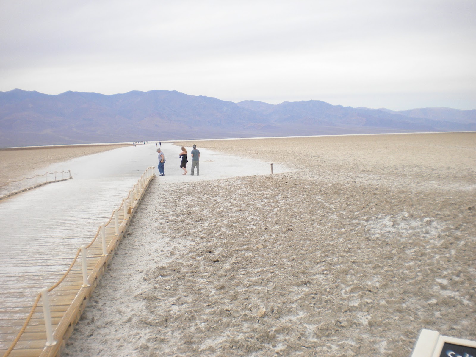
After they got over the mountains and down into the Valley, this is one of the views they saw. These are the salt flats that were left behind when a huge lake dried up many, many years ago.

After driving for many miles, they came to Badwater Basin, the lowest point in elevation in North America, and 282' below sea level.
 This next photo is looking out over Badwater Basin

If you click on this next photo, you'll see a sign way up there on the side of the mountain. The sign says "Sea Level"..

From Badwater, they continued on towards the Furnace Creek and saw some more interesting sights along the way. One road they went on was called "Artist Drive".

This is a 1 lane one-way road leading back into the mountains and it is restricted to vehicles of less than 25' CLT says that there was a small Motor Home on the road and he was having difficulties maneuvering through the narrow passages between the rocks.
About half way through the nine mile drive, there's an area called "Artist Palette", which CLT says is really neat. You can't see it too well in the photos below, but the different sections of the rock are different colors. Some red, blue, green, and of course many shades of brown.
 I think if the sun would have been shinning when Jim took these pictures, the colors would have stood out more.

A little after Artist Drive, they came to Furnace Creek where they turned right and headed back here to the Park. It was about about 2:00 by the time they got back and poor little CLT had traveled about 150 miles, much of it up and down mountains!!!
No wonder CLT was dragging his tail gate by the time he returned!!!! ; O
All in all, both Jim and Linda said it was a great day. They really enjoyed the scenery and are glad they went back to see the valley from the bottom. Death Valley is a great place to visit and you can probably spend many days seeing everything there is to see in the park. Be advised though, during the summer months, it's not uncommon for the temperatures to get well over 100 degrees.
Most seem to agree, that the spring or fall are the ideal times to visit. Today for instance, the temperature down in the valley was about 75 to 80 degrees.
Just right for a nice drive through the park. : )
Did you know that the record high temperature in Death Valley is 134 degrees, set in July of 1913?
48 deg. clear, no wind.
Forecast = Partly cloudy. High of 79F. Winds less than 5 mph.
Poor little CLT! He really had a busy day yesterday and by the time he returned here to the RV Park in Tecopa, his little tail gate was almost dragging the ground!!!! ; )
"Why was that?" you ask.
Well, Jim and Linda decided to head back to Death Valley and this time, go to the bottom of the valley to see it, instead of looking at it from above, and CLT had to get them there. So, , , , , , about 9:45 they hopped into CLT and took off.
Now to get to the bottom of Death Valley, you first have to go up and over some mountains to get down into the valley, and that's what almost did poor CLT in. We're at about 1300' here at the RV Park and the mountains that you have to cross are over 3000'. And, as most of you know, Death Valley is quite a ways below sea level. : (
So, off they went.
Just past Shoshone, they turned off of Route 127 onto Rt 178 and followed it West.


This is a 1 lane one-way road leading back into the mountains and it is restricted to vehicles of less than 25' CLT says that there was a small Motor Home on the road and he was having difficulties maneuvering through the narrow passages between the rocks.
About half way through the nine mile drive, there's an area called "Artist Palette", which CLT says is really neat. You can't see it too well in the photos below, but the different sections of the rock are different colors. Some red, blue, green, and of course many shades of brown.


No wonder CLT was dragging his tail gate by the time he returned!!!! ; O
All in all, both Jim and Linda said it was a great day. They really enjoyed the scenery and are glad they went back to see the valley from the bottom. Death Valley is a great place to visit and you can probably spend many days seeing everything there is to see in the park. Be advised though, during the summer months, it's not uncommon for the temperatures to get well over 100 degrees.
Most seem to agree, that the spring or fall are the ideal times to visit. Today for instance, the temperature down in the valley was about 75 to 80 degrees.
Just right for a nice drive through the park. : )
Did you know that the record high temperature in Death Valley is 134 degrees, set in July of 1913?
Wednesday, March 28, 2012
Nothing Much Happening
Tecopa, CA.
54 deg. clear, N. wind @ 2 mph.
Forecast = Partly cloudy. High of 75F. Winds from the NE at 5 to 10 mph.
There was nothing much planned for Monday except to do laundry. Well, that's about all that happened. Jim was out and about visiting with neighbors, playing with the computer and just kicking back. Linda did laundry, read some and worked on her Family Tree Maker program.
Yesterday, the plan was to go back to Death Valley to check out some more sights, but Jim woke up with a plugged ear and really didn't feel too well, so those plans were scrapped.
Instead, they took a ride, first into Tecopa to mail a letter and then up to Shoshone to buy some 87 octane for CLT and some bread and chips.
Oh, and the price of gas, 30 miles from nowhere and at the only station for many miles around?
$5.29 !!!!!!!
Now, the price of gas in California is high, but not that high. They just charge that much because they're the only station around and people have to pay it. : ( Then next closest station is in Pahrump, NV., about 25 miles east of Shoshone, (where I'm told it's much cheaper), or in Death Valley itself, where the price is even higher!!!
Jim's feeling better today, so I think they're going to head into Death Valley. It should be interesting, and I'm counting on Jim taking some more photos so I can post them here.
A Point to Ponder : The only place you'll find success before work is in the dictionary.
Monday, March 26, 2012
What A Windy Day!!
Tecopa, CA.
44 deg. partly cloudy, SE wind @ 10 mph.
Forecast = Partly cloudy. High of 64F. Winds less than 5 mph.
Whew!!!! What a windy day yesterday!!! Dust everywhere, things being blown around in the park and at the same time, people trying to do things, like get ready to leave the park for the season or just get over to the clubhouse for the hot dog roast the CG owners had yesterday.
It wasn't too bad in the morning and Jim was out and about talking to the neighbors. He's become pretty good friends with Andy and Mary who have the old Midas Motor Home parked on my right side.
They leave the MH here and come back every year for 6 months. Mary does things with stones and rocks and Andy helps her scour the desert to find the stones and gems she wants. When they're not here, they have a house up in the mountains, someplace near Sacramento, CA.
Many, many years ago, Andy used to do a lot of motocross racing and now he's paying for it with bad hips and knees.
In fact, Jim and Andy spent some of the day over at the clubhouse watching the NASCAR race on TV. I never did find out how the race turned out after it was stopped for rain.
I guess I'll have to check on the Internet after I get done writing this.
Anyway, it was about noon when the wind started picking up and it just kept getting stronger and stronger as the day went on. (I'm sure we had gusts in the 50 mph range). It was still blowing at 10:00 pm but died down sometime during the night.
Oh, and I mentioned the hot dog roast over at the clubhouse. Well, Mike and Marie, (the park owners), decided that they were going to roast hot dogs on the grill and invited everyone in the park to come over and have some. Some people brought relish, mustard and catchup, and someone even brought some beans.
Luckily the wind hadn't picked up too much by noon and it sounds like a good time was had by all. : )
While Jim and Andy were over at the clubhouse watching the race, Linda was doing laundry and reading. By mid-afternoon, no one was outside except a few RVers who had to walk their dogs.
Today, I don't think Jim and Linda have much planned. I'm pretty sure that tomorrow they're going back to Death Valley again to see more of the sights, and then on Wednesday or Thursday, they're planning on going to get groceries.
A Point to Ponder : Be sure you put your feet in the right place, then stand firm.
Sunday, March 25, 2012
First Trip Into Death Valley
Tecopa, CA.
46 deg. clear, no wind.
Forecast = Partly cloudy in the morning, then mostly cloudy with a chance of rain. High of 66F. Winds from the East at 5 to 15 mph with gusts to 30 mph. Chance of rain 40%.
After starting the day with a sunrise like this, Jim just knew it had to be a good day for exploring parts of Death Valley. : )
 So, after packing some things to take along, (a water jug filled with ice water, some snacks and a lunch for Linda), they headed towards the valley.
The road getting to Death Valley is in very good condition and there's lots of pull-off places where you can stop to take photos or have a drink of that nice cool water that you brought along.
 This is one of the first markers they came to. If you click on this photo, or any of the others, they will enlarge.
 The above marker was just a little ways before they came to the Furnace Creek Visitor Center where they went inside and looked at some of the exhibits and got maps and brochures about Death Valley from the park rangers.
 After having some lunch and studying the maps and brochures, it was decided that they would check out something that Jim had read and heard about.
They had decided to go to the area known as Dantes View!!!
From the Visitors Center, they came back the way they had come until they came to the sign pointing to Dantes View. As soon as they turned off of the main road, there was a sign saying that the last 1/4 mile of this 13 mile road had a 17% grade!!!!!!
Yep, you read that right. 17%!!!!!!!
CLT said that the road was in good condition, but there were lots of twists and curves and he was gaining altitude all the way. About 2/3 of the way there, there was a sign saying that no trailers were allowed further down the road and that there was a parking place for them if you wanted to continue.
Past that point, CLT says the road became more twisty with some hair-pin turns and the grade got steeper. And, true to that first sign, the last 1/4 mile was at a 17% grade!!!!
CLT said that at times he felt like he was going straight up!!! He said that Jim had to put his transmission way down into 1st gear to get up to the top!!!
 But, he made it, and Oh Boy!!!! What a view he had when he got there!!!!
Dantes View is at 5475' above sea level and the bottom of the valley that you see in the photos is 282' below sea level.

 CLT says that the above photos don't really show the depth of the valley or the beautiful shades of color, but I'm hoping you can get an idea of what it was like. It's like many places, you can't really see or know what it's like unless you go there and experience it for yourself.
Then, after taking in the view, it was time to start heading back down. The photo below shows only a small portion of the road, but maybe you can get an idea of what it was like. CLT said that the speed limit going down on the first steep section of road was 10 MPH and he said the definitely wouldn't have wanted to go any faster than that. : O
 It was about 3:00 by the time Jim, Linda and CLT returned here to the park. Jim and Linda were both talking about how great the day was and how much they enjoyed it.
After relaxing a bit, they both took naps. ; )
As for CLT, I think he was just plain tired from doing all that climbing. I didn't hear a thing from him until later in the evening. ; )
Did you know that Mt. Whitney at 14,491 feet above sea level, (the highest point in the lower 48 states), and Death Valley at 282 feet below sea level, (the lowest point in the lower 48 states), are only about 100 miles apart?
46 deg. clear, no wind.
Forecast = Partly cloudy in the morning, then mostly cloudy with a chance of rain. High of 66F. Winds from the East at 5 to 15 mph with gusts to 30 mph. Chance of rain 40%.
After starting the day with a sunrise like this, Jim just knew it had to be a good day for exploring parts of Death Valley. : )

The road getting to Death Valley is in very good condition and there's lots of pull-off places where you can stop to take photos or have a drink of that nice cool water that you brought along.


They had decided to go to the area known as Dantes View!!!
From the Visitors Center, they came back the way they had come until they came to the sign pointing to Dantes View. As soon as they turned off of the main road, there was a sign saying that the last 1/4 mile of this 13 mile road had a 17% grade!!!!!!
Yep, you read that right. 17%!!!!!!!
CLT said that the road was in good condition, but there were lots of twists and curves and he was gaining altitude all the way. About 2/3 of the way there, there was a sign saying that no trailers were allowed further down the road and that there was a parking place for them if you wanted to continue.
Past that point, CLT says the road became more twisty with some hair-pin turns and the grade got steeper. And, true to that first sign, the last 1/4 mile was at a 17% grade!!!!
CLT said that at times he felt like he was going straight up!!! He said that Jim had to put his transmission way down into 1st gear to get up to the top!!!

Dantes View is at 5475' above sea level and the bottom of the valley that you see in the photos is 282' below sea level.


Then, after taking in the view, it was time to start heading back down. The photo below shows only a small portion of the road, but maybe you can get an idea of what it was like. CLT said that the speed limit going down on the first steep section of road was 10 MPH and he said the definitely wouldn't have wanted to go any faster than that. : O

After relaxing a bit, they both took naps. ; )
As for CLT, I think he was just plain tired from doing all that climbing. I didn't hear a thing from him until later in the evening. ; )
Did you know that Mt. Whitney at 14,491 feet above sea level, (the highest point in the lower 48 states), and Death Valley at 282 feet below sea level, (the lowest point in the lower 48 states), are only about 100 miles apart?
Saturday, March 24, 2012
Out Of Nevada And Back Into California
54 Deg. clear, NE wind @ 5 mph.
Forecast = Partly cloudy. High of 75F. Winds from the ESE at 5 to 15 mph with gusts to 30 mph
Because they were forecasting some possible windy conditions later on in the day, we left the Cal-Nev-Ari RV Park earlier than usual, (about ), and continued North on US95.
When we came to the town of Searchlight
 It’s kind of like riding a roller-coaster and it’s necessary to give full attention to the driving. Once we crossed into
 California Nipton
Yes, up into those mountains in the photo above. ; )

Yes, up into those mountains in the photo above. ; )
Turning West on 15, it was still more climbing for another 15 miles or so, before we started going down again, all the way to Baker.
Once to Baker, we turned North on CA127,
 and brought it up to the Old Spanish Trail Road, which took us into Tecopa and the Petersen’s Tecopa Palms RV Park, where Jim had made reservations for me.


CA127 is a very good road with very smooth pavement, but again it had lots of humps and dips and was very curvy and hilly in places.
It was 1 when we pulled into the park, so it took us about 2 hours and 50 minutes to travel 133 miles. Not too bad considering we slowed down for the dips and humps on the roads.
Petersen’s Tecopa Palms RV Park is a very well maintained park, and the owners are supper friendly and willing to help in any way they can. I’ve got one of the longer sites in the park and in fact, there’s a whole vacant area behind me.

I’ve got full hook-ups with 50 amp electric and a great view of the mountains off to my right, left, front and rear. ; )


I’ve got full hook-ups with 50 amp electric and a great view of the mountains off to my right, left, front and rear. ; )

I think I’m going to like it here for the next week. : )
A Point to Ponder : Character consists of what you do on the third and fourth tries.
Friday, March 23, 2012
Cal-Nev-Ari
54 deg. clear, S. wind @ 4 mph
Forecast = Clear. High of 82F. Winds from the South at 10 to 20 mph. Breezy.
We left the short term Boon-docking area just North of Quartzsite about and headed North on AZ 85. When we got up to Parker, we crossed the
Staying with 95 brought us up to
We arrived at , so it took us 2 hours and 35 minutes to travel the 135 miles up here.


So, , , , , , back here they came and popped a couple of TV Dinners into my microwave. It was a meal, but not what they were wanting. : (
Jim called the RV Park outside of Death Valley where I will be staying while they go into the valley to explore, and asked if it would be alright if we would come tomorrow instead of Sunday as planned. The lady that he talked to said that it would be fine if we came early as their park is not busy at all.
Hmmmm….I wonder of the high price of gas and diesel has anything to do with it?
Did you know that Cal-Nev-Ari was created in the mid 1960s by Nancy and Slim Kidwell, who acquired a 640-acre section of land from the U. S. government and commenced development of an airport-based community? In addition to the FAA-designated Kidwell Airport, the community has grown over the years to include a casino, motel, RV and mobile home parks, convenience market, and over 100 residential lots.
Thursday, March 22, 2012
Movin' On
Quartzsite, AZ.
46 deg. clear, no wind.
Forecast = Clear. High of 88F. Winds from the SSE at 5 to 10 mph.
Just a quick note to let you know that we're movin' on. We've enjoyed our stay here out in the desert, but the forecast for today is in the mid to upper 80's and Jim and Linda think it's time to get going.
I'll have to admit, if we stayed here, Jim would have to run my generator a lot to keep it anywhere near cool inside of me. With outside temperatures in the mid- 80's, no shade, and sitting out in the desert, I'm sure it would get into the 90's or more inside of me real quick, if there was no AC.
So, where do we go from here? Well, there's a couple of possibilities. There's a RV Park up near Needles, and there's another up into Nevada, so it'll probably be one of those. Both are between 100 and 150 miles from here.
Yesterday Jim and Linda took CLT and headed into town. They got CLT a drink of 87 octane, bought some goodies at a bakery, and bought a few more items at a grocery store.
Again, I don't know if I'm going to have any Internet signal, so hang in there, I'll post when I can. ; )
Did you know that the original London Bridge was shipped stone-by-stone and reconstructed in Lake Havasu City, AZ?
Wednesday, March 21, 2012
Maricopa To Quartzsite and Boon-docking
Quartzsite, AZ
41 deg. clear, no wind
Forecast = Clear. High of 79F. Winds less than 5 mph.
Well, they must have installed a new tower or something since Jim and Linda were here the last time because I'm able to get on the Internet. I only have a weak signal. and it's very slow, but at leas I can do a little posting.
We left the John Wayne RV Ranch near Maricopa at 9:55 and took Rt. 84 west for a few miles until it connected with I-8. Once on 8, we continued West until we came to Gila Bend where we turned North on Rt. 85. After about 35 miles, we came to I-10 where we tuned West again and followed it to Quartzsite, AZ.
Once in town on Business I-10, Jim ;pulled me into a Pilot station and bought me a drink of #2 diesel fuel. I wasn't real thirsty, but at $4.38 a gallon, it cost quite a bit to fill me up. : (
After stopping for my drink, we went back to the center of town and turned North on AZ Rt. 95. We followed it for about 5 1/2 miles and then turned off on Plomosa Rd and the Plomosa short term boon-docking area.
It was 1:30 when we got here, so it took us 3 hours and 35 minutes to travel 172 miles and stop for my drink.
After registering and getting a paper to put on my windshield, (no charge), we went about a mile farther East where Jim pulled me off of the road and out into the desert!!!
After pulling out into the desert for aways, Jim got out and checked out the area and decided on a spot to park me. Then he unhooked CLT from the back of me, and turned me around and backed me onto the spot he had chosen.
The main concern was to get me positioned so that the sun wasn't shining into my windshield during the hottest part of the day.
 I still don't know about this Boon-docking thing. I made it through the night OK without draining my batteries too much, but soon Jim will have to start my generator again to get them charged up for the day.
So far, he has run my generator for about an hour at dinner time, so that Linda could use the stove, and another hour just before they went to bed.
Oh, we were treated to a pretty nice view of the sunset last night. There weren't many clouds, but I like the silhouette effect. ; )

Did you know that the saguaro cactus blossom is the official state flower of Arizona?. The white flower blooms on the tips of the saguaro cactus during May and June. The saguaro is the largest American cactus.
41 deg. clear, no wind
Forecast = Clear. High of 79F. Winds less than 5 mph.
Well, they must have installed a new tower or something since Jim and Linda were here the last time because I'm able to get on the Internet. I only have a weak signal. and it's very slow, but at leas I can do a little posting.
We left the John Wayne RV Ranch near Maricopa at 9:55 and took Rt. 84 west for a few miles until it connected with I-8. Once on 8, we continued West until we came to Gila Bend where we turned North on Rt. 85. After about 35 miles, we came to I-10 where we tuned West again and followed it to Quartzsite, AZ.
Once in town on Business I-10, Jim ;pulled me into a Pilot station and bought me a drink of #2 diesel fuel. I wasn't real thirsty, but at $4.38 a gallon, it cost quite a bit to fill me up. : (
After stopping for my drink, we went back to the center of town and turned North on AZ Rt. 95. We followed it for about 5 1/2 miles and then turned off on Plomosa Rd and the Plomosa short term boon-docking area.
It was 1:30 when we got here, so it took us 3 hours and 35 minutes to travel 172 miles and stop for my drink.
After registering and getting a paper to put on my windshield, (no charge), we went about a mile farther East where Jim pulled me off of the road and out into the desert!!!
After pulling out into the desert for aways, Jim got out and checked out the area and decided on a spot to park me. Then he unhooked CLT from the back of me, and turned me around and backed me onto the spot he had chosen.
The main concern was to get me positioned so that the sun wasn't shining into my windshield during the hottest part of the day.

So far, he has run my generator for about an hour at dinner time, so that Linda could use the stove, and another hour just before they went to bed.
Oh, we were treated to a pretty nice view of the sunset last night. There weren't many clouds, but I like the silhouette effect. ; )

Did you know that the saguaro cactus blossom is the official state flower of Arizona?. The white flower blooms on the tips of the saguaro cactus during May and June. The saguaro is the largest American cactus.
Tuesday, March 20, 2012
New Electric Heater Dies and Plans
Maricopa, AZ
38 deg. clear, no wind.
Forecast = Clear. High of 61F. Winds from the West at 5 to 10 mph shifting to the NNE in the afternoon.
I don't know if you remember or not, but back on the 2nd of March, Jim went to Home Depot and bought an electric space heater to replace the old one that had died. Well, now the new one died!!! : ( Sunday evening, we had a power outage here at the park. It didn't last long, but when the power came back on, the little red light on the heater didn't come back on, and in fact, nothing on the heater would work at all.
Jim called the customer service number and talked to a nice lady who asked him some questions. One of the questions was, "Do you know if you had a power outage or a surge"? Jim told her we had the power outage and she told him that that is more than likely what messed up the heater. She asked where Jim had bought it, and told him to just take it back to Home Depot and they would refund his money.
Now, all of you RVers out there know that the power in many RV parks is not real reliable and there are power outages at times. So, , , , if you're looking for an electric space heater, I don't recommend that you buy a Lasko heater with digital readout, as it seems like the electronics can't tolerate interruptions in service.
Jim and Linda really liked the heater and it did a fine job of heating the inside of me, but if it's that sensitive, it's probably not well suited for RV use.
So, yesterday morning, Jim and Linda took the heater back to a Home Depot in Casa Grande, and they refunded the money without hesitation. Jim then asked the lady at customer service if they had any other heaters in stock? She told him that they hadn't had any left for about 3 weeks!! : (
Jim really wanted to get another heater, so on the way back here, they stopped by an ACE Hardware Store and Jim went in to check. Well, they had some left, but not any tower heaters like he had. But, they did have some "Pelonis Safe-T-Furnace Ceramic Heaters", so Jim bought one.
This is a much smaller heater, but it sure puts out the heat!! : ) It's been running all night, the temperature outside is down in the 30's but it's 72 degrees inside of me!!!
I think it's going to be just fine!!! : ) And, it doesn't have all the electronic readouts and controls, so a power outage shouldn't bother it. ; )
We're leaving here this morning and because of where we'll be going, I doubt if I'm going to be able to post every day for awhile. In fact, I doubt if I'll be posting much at all in the near future.
Here are the plans for the next couple weeks.
From here in Maricopa, we'll be heading to Quartzsite for a few days to do a little book-docking. Like I said yesterday, that will be a new experience for me, but I have confidence that I can handle it, for a few days at least.
From "Q", (as it's known in the RVing community), the plan is to head up to the Needles, CA area. There's an RV park up there that Jim and Linda have been to before, and if things go according to plan, we'll stay there for a day or two.
From there, we'll be heading to Tecopa, CA which is just outside of the Death Valley NP. Jim has found a park there that can accommodate me and has made a reservation for 1 week, starting on Sunday, the 25th of this month, (which is less than a week from now). The name of the park is Peterson's Tecopa Palms RV Park and has very good Reviews on RV Park Reviews. It is however, far away from any large towns or cities, so cell / Internet service may not be available.
From this park the plan is for Jim and Linda to take CLT and explore Death Valley on day trips.
Jim had originally planned on taking me into Death Valley and to one of the NP Campgrounds inside of the park, but one of the Campgrounds is closed for maintenance, and there are length or generator restrictions in some of the others. Also, it seems like this is one of the busiest times of the year for visitors to Death Valley, (because of the weather and "spring break"), so many of the campgrounds inside of the park will more than likely be full.
Now, I know some of you are wondering why on earth Jim and Linda would want to go to a place like Death Valley. There's nothing to see there, it's hot, it's dry, it barren, there's nothing growing there, no wildlife, and did I mention, it's Hot and Dry????
Well, Jim and Linda have wanted to see DV for quite some time now, (especially Jim), since it's one of the National Parks that they've not been to, and Jim seems to think that there are quite a few things to see. He's done quite a bit of research on the park and has come to the conclusion that it's worth spending some time exploring.
So, until April 1st, at least, I have no idea if I'll have any kind of Internet connection. In fact Jim and Linda are not sure if they'll even have cell phone service. So, you may not hear from me or them for awhile.
Have no fear though, I'll keep track of my wanderings and what's going on and will up-date you as soon as possible. And who knows, maybe I'll be able to post as usual! : )
Did you know that at one time camels were used to transport goods across Arizona?
Monday, March 19, 2012
More Rain And Wind
Maricopa, AZ
40 deg. overcast, SW wind @ 7 mph.
Forecast = Partly cloudy with a chance of rain. High of 54F. Winds from the West at 5 to 20 mph. Chance of rain 30%.
It didn't rain all day, but the wind did blow pretty much of the day. : ( The rain was very spotty and it never did rain very hard. The wind however blew pretty hard until the evening hours when it finally died down some. Jim did take the garbage down to the dumpster in the middle of the afternoon, but other than that, stayed inside and watched the NASCAR race on TV and took a little nap.
Linda watched the race some too, but spent most of the afternoon working with her Family Tree Maker program.
We'll be staying here for one more day. When we arrived, Jim paid for 3 nights so that means we'll leave here tomorrow.
From here, I think we're heading for Quartzsite, AZ. Don't know for sure, but I think Jim and Linda are planning on doing a little boon-docking. I know they've been there before, but I've never just "parked" out in the desert, so it'll be a new experience for me.
Did you know that Arizona observes Mountain Standard Time on a year round basis? The one exception is the Navajo Nation, located in the northeast corner of the state, which observes the daylight savings time change.
Sunday, March 18, 2012
Talk About Timing
Maricopa, AZ
45 deg. cloudy, light rain, windy.
Forecast = Overcast with a chance of a thunderstorm and rain showers. High of 64F. Winds from the SW at 5 to 20 mph with gusts to 30 mph. Chance of rain 80% with rainfall amounts near 0.2 in. possible.
We had a lot of wind go through here last night!!! The gusts had to be well over 50 mph and I'm sure glad that Jim and Linda had brought my slides in, cause I don't think there would be anything left to the slide-out awnings this morning!!!!
Before I get to the main part of this post, I want to share some photos of the Benson I-10 RV Park.
This first one is of the office / laundry.

This next photo is a view of the park from the office area.

My site had a cement patio with a picnic table.
 All in all, a pretty nice park.
Now back to the Title of this post.
Both Jim and Linda decided that an early start to yesterday's travels would be best. The forecast was for strong winds with gusts to over 40 mph, but most reports agreed that the winds wouldn't start blowing in earnest until later in the morning.
So, , , , , , ,at 8:25 we pulled out of the Benson I-10 RV Park and continued our westward wanderings. The sun was shining and there was a little breeze blowing, but nothing that I could even feel. When we came to Tucson, the traffic became a little heavier, but other than one slowdown, we moved right along.
When we came to the junction of I-10 and I-8, we turned West on I-8 and followed it to exit 161 where we turned North for about 3 miles. There, we came to US 84 where we tuned West. After 5 miles we came to the John Wayne RV Ranch on the left side of the road.
It was 10:30 when we pulled up to the stop sign at the office, so it took us 2 hours and 5 minutes to travel 128 miles.
Now, this is where the timing comes in. Just after we turned off of I-8 at exit 161, the wind picked up a little, and about 15 minutes after I was in my site here at the park, it really started blowing!!
By dinner time, the winds had picked up to about 30 mph with gusts to 45 mph. : (
This is a nice park. The folks in the office were supper friendly and Gene, (the man who led me to my site and helped Jim position me), was really friendly and helpful too.
Again, this is a desert RV Park and there's no grass. There's some small trees and they've landscaped where they could. The photo below is what you see when you come into the park. As you can see there's cactus and a few trees.

The shuffleboards (the green cement at the far left of the photo), and horse shoe pits.

My site, you can see how large it is. It has full hook-ups, 50 amp electric free wi-fi, and of course is a pull-through that is long enough for me and CLT.

A view down the street in front of me.
 I don't know for sure, but I don't think this park has anything to do with "John Wayne", the movie star. There's no reference to him that I've seen. Maybe I can get Jim to ask at the office where the name came from.
Did you know that there is a possible 25 years in prison for cutting down a cactus in Arizona?
45 deg. cloudy, light rain, windy.
Forecast = Overcast with a chance of a thunderstorm and rain showers. High of 64F. Winds from the SW at 5 to 20 mph with gusts to 30 mph. Chance of rain 80% with rainfall amounts near 0.2 in. possible.
We had a lot of wind go through here last night!!! The gusts had to be well over 50 mph and I'm sure glad that Jim and Linda had brought my slides in, cause I don't think there would be anything left to the slide-out awnings this morning!!!!
Before I get to the main part of this post, I want to share some photos of the Benson I-10 RV Park.
This first one is of the office / laundry.


Now back to the Title of this post.
Both Jim and Linda decided that an early start to yesterday's travels would be best. The forecast was for strong winds with gusts to over 40 mph, but most reports agreed that the winds wouldn't start blowing in earnest until later in the morning.
So, , , , , , ,at 8:25 we pulled out of the Benson I-10 RV Park and continued our westward wanderings. The sun was shining and there was a little breeze blowing, but nothing that I could even feel. When we came to Tucson, the traffic became a little heavier, but other than one slowdown, we moved right along.
When we came to the junction of I-10 and I-8, we turned West on I-8 and followed it to exit 161 where we turned North for about 3 miles. There, we came to US 84 where we tuned West. After 5 miles we came to the John Wayne RV Ranch on the left side of the road.
It was 10:30 when we pulled up to the stop sign at the office, so it took us 2 hours and 5 minutes to travel 128 miles.
Now, this is where the timing comes in. Just after we turned off of I-8 at exit 161, the wind picked up a little, and about 15 minutes after I was in my site here at the park, it really started blowing!!
By dinner time, the winds had picked up to about 30 mph with gusts to 45 mph. : (
This is a nice park. The folks in the office were supper friendly and Gene, (the man who led me to my site and helped Jim position me), was really friendly and helpful too.
Again, this is a desert RV Park and there's no grass. There's some small trees and they've landscaped where they could. The photo below is what you see when you come into the park. As you can see there's cactus and a few trees.


My site, you can see how large it is. It has full hook-ups, 50 amp electric free wi-fi, and of course is a pull-through that is long enough for me and CLT.

A view down the street in front of me.

Did you know that there is a possible 25 years in prison for cutting down a cactus in Arizona?
Saturday, March 17, 2012
Crossing The Continental Divide and Nasty Weather On The Way
Benson, AZ
41 deg. clear, no wind.
Forecast = Partly cloudy. High of 77F. Winds from the SSW at 10 to 15 mph with gusts to 40 mph.
Forecast tonight = Mostly cloudy with a chance of rain, then rain showers after midnight. Low of 46F. Winds from the SSW at 15 to 20 mph with gusts to 30 mph. Breezy. Chance of rain 60%.
 We left the SKP Dreamcatcher RV park in Deming right at 10:00 and headed for I-10. We took 10 to the west side of town where Jim pulled me into the Deming Truck Terminal. There he bought me a nice drink of #2 diesel. He had looked on the Internet and determined that fuel was cheaper in NM than in AZ. Even at that, the price here was $4.09 per gallon. : (
From the Truck Stop, we continued West on I-10. It was a nice day with no wind and not much traffic, so the trip went well.
As we headed across New Mexico, I saw a sign that said that we were crossing the Continental Divide!!
What????? I didn't even go over a hill!!! Right out there where the land is almost flat, we crossed the Divide!!!!
I really don't get it, there were mountains all around us and yet they say the divide is in between them!!!! ????
Anyway, the road was good except for the last 20 miles or so in AZ, and then it wasn't really bad, just a little rough in places with some dips.
It was 1:00 when I pulled up to the stop sign near the office of the Benson I-10 RV Park, so it took us almost exactly 3 hours to drive 169 miles and get me my drink.
This is a nice park, especially since it's a Passport America Park and I'm staying here for $16.50 per night ; ) . It's a typical desert park, all gravel with a few small trees, a cement patio with a picnic table and full hook-ups with 50 amp electric. Most of the sites here are pull-through and the one I'm in is long enough for me and CLT.
Jim took some photos, but the AT&T air card Internet connection is so slow here, I can't get them to load. : (
For dinner, Jim and Linda went across the road to a Denny's Restaurant. The park owner has some kind of deal with them and if you show your paid RV Park receipt you get 10% off of the bill. : ) When they came back they both said their meals were good.
Today, we'll head further West, probably to the Casa Grande area, (about 2 1/2 hours away), South of Phoenix. I think we'll be leaving here pretty early because they're forecasting very strong winds with blowing dust starting about 10:00 or 11:00. In fact, this whole weekend is suppose to be pretty nasty with very high winds, (40+ MPH gusts), rain, falling temperatures and even snow above about 3500'. (We're at about 3600 feet here in Benson, Casa Grande is below 1500'.) : (
Did you know that traditional St Patrick’s Day food includes, Irish soda bread, corned beef and cabbage, Irish stew, and of course, Guinness?
41 deg. clear, no wind.
Forecast = Partly cloudy. High of 77F. Winds from the SSW at 10 to 15 mph with gusts to 40 mph.
Forecast tonight = Mostly cloudy with a chance of rain, then rain showers after midnight. Low of 46F. Winds from the SSW at 15 to 20 mph with gusts to 30 mph. Breezy. Chance of rain 60%.
From the Truck Stop, we continued West on I-10. It was a nice day with no wind and not much traffic, so the trip went well.
As we headed across New Mexico, I saw a sign that said that we were crossing the Continental Divide!!
What????? I didn't even go over a hill!!! Right out there where the land is almost flat, we crossed the Divide!!!!
I really don't get it, there were mountains all around us and yet they say the divide is in between them!!!! ????
Anyway, the road was good except for the last 20 miles or so in AZ, and then it wasn't really bad, just a little rough in places with some dips.
It was 1:00 when I pulled up to the stop sign near the office of the Benson I-10 RV Park, so it took us almost exactly 3 hours to drive 169 miles and get me my drink.
This is a nice park, especially since it's a Passport America Park and I'm staying here for $16.50 per night ; ) . It's a typical desert park, all gravel with a few small trees, a cement patio with a picnic table and full hook-ups with 50 amp electric. Most of the sites here are pull-through and the one I'm in is long enough for me and CLT.
Jim took some photos, but the AT&T air card Internet connection is so slow here, I can't get them to load. : (
For dinner, Jim and Linda went across the road to a Denny's Restaurant. The park owner has some kind of deal with them and if you show your paid RV Park receipt you get 10% off of the bill. : ) When they came back they both said their meals were good.
Today, we'll head further West, probably to the Casa Grande area, (about 2 1/2 hours away), South of Phoenix. I think we'll be leaving here pretty early because they're forecasting very strong winds with blowing dust starting about 10:00 or 11:00. In fact, this whole weekend is suppose to be pretty nasty with very high winds, (40+ MPH gusts), rain, falling temperatures and even snow above about 3500'. (We're at about 3600 feet here in Benson, Casa Grande is below 1500'.) : (
Did you know that traditional St Patrick’s Day food includes, Irish soda bread, corned beef and cabbage, Irish stew, and of course, Guinness?
Friday, March 16, 2012
A Little Cleaning, A Potluck Dinner and A Little Music
Deming, NM.
41 deg. clear, no wind.
Forecast = Partly cloudy in the morning, then clear. High of 79F. Winds from the WSW at 5 to 10 mph
Jim was up and busy cleaning the inside of me before Linda even woke up. He cleaned the bathroom, shook out the throw rugs and swept the floors and had it all done by about 9:00.
It wasn't a real thorough job of cleaning, but lets face it, we're going to be in the desert for the next week or so, and I'm sure there'll be a lot more dust and sand getting inside of me during that time. ; )
Being that they had signed up to go to the potluck at the park Clubhouse, Linda put together a green bean casserole and partially cooked it in my oven after she got up and had her breakfast. Then, after lunch, Jim and Linda took CLT and headed into town to mail a form to the bank and scope out a place where I could get into to get a drink of #2 diesel.
They mailed the form and found a truck stop at the West edge of Deming where I can get that drink this morning, when we leave here.
Yep, that right. We're leaving here already this morning. I sure wish we could have stayed longer, but as most of you know, plans do change. : (
Also after lunch, Jim tightened up my alternator belt. It was squealing a little at times when my engine was first started. It didn't take him long to snug it up and soon he was done and inside, taking a nap. ; )
About 5:00, Linda finished cooking the casserole and then about 5:45, she and Jim took CLT and headed over to the Clubhouse.
From what I understand, the potluck was a great success and there was more food than could be eaten. Quite a few people attended and Jim and Linda said they thought everyone enjoyed the meal.
Then as an added bonus, a group started playing music after the meal. There were 5 in the group and they played and sang a wide variety of songs. They must have been pretty good because I could hear the clapping way over here at my site. ; )
 About 7:30 Jim and Linda came back here, watched some TV and then went to bed after the news.
 Did you know that Leprechauns are the official shoe makers of the fairy kingdom?
41 deg. clear, no wind.
Forecast = Partly cloudy in the morning, then clear. High of 79F. Winds from the WSW at 5 to 10 mph
Jim was up and busy cleaning the inside of me before Linda even woke up. He cleaned the bathroom, shook out the throw rugs and swept the floors and had it all done by about 9:00.
It wasn't a real thorough job of cleaning, but lets face it, we're going to be in the desert for the next week or so, and I'm sure there'll be a lot more dust and sand getting inside of me during that time. ; )
Being that they had signed up to go to the potluck at the park Clubhouse, Linda put together a green bean casserole and partially cooked it in my oven after she got up and had her breakfast. Then, after lunch, Jim and Linda took CLT and headed into town to mail a form to the bank and scope out a place where I could get into to get a drink of #2 diesel.
They mailed the form and found a truck stop at the West edge of Deming where I can get that drink this morning, when we leave here.
Yep, that right. We're leaving here already this morning. I sure wish we could have stayed longer, but as most of you know, plans do change. : (
Also after lunch, Jim tightened up my alternator belt. It was squealing a little at times when my engine was first started. It didn't take him long to snug it up and soon he was done and inside, taking a nap. ; )
About 5:00, Linda finished cooking the casserole and then about 5:45, she and Jim took CLT and headed over to the Clubhouse.
From what I understand, the potluck was a great success and there was more food than could be eaten. Quite a few people attended and Jim and Linda said they thought everyone enjoyed the meal.
Then as an added bonus, a group started playing music after the meal. There were 5 in the group and they played and sang a wide variety of songs. They must have been pretty good because I could hear the clapping way over here at my site. ; )

Thursday, March 15, 2012
The Dream Catcher RV Park
Deming, NM
35 deg. clear, no wind.
Forecast = Clear in the morning, then overcast. High of 77F. Winds from the NNW at 5 to 10 mph shifting to the ESE in the afternoon.
Jim and Linda took CLT and headed to a Grocery store yesterday morning. They didn't need much, but were out of a few essentials. After lunch, Linda put a load of laundry in my washer/dryer while Jim fooled around outside and took a few photos of the park and the surrounding area.
Jim and Linda like this Escapees RV Club park. It's nothing special as far as parks go, but there's a friendly bunch of people here and they've always enjoyed being here.
This first photo is of the entrance to the park.

As soon as you turn into the park you come to the Office/Clubhouse. Jim and Linda said that when they first came here, it was much smaller than it is now.

This is a view of the CG as you leave the Office. Most of the sites are pull-through with full hook-ups. As you can see there weren't a real lot of RVs here when Jim took the photo, but it's getting late in the season for people to be staying for long stretches and actually by late afternoon, there's quite a few more here.

This last photo was taken looking kind of SE from the park in the evening. It was kind of hazy when Jim took this, but I liked the way the setting sun was creating shadows on the mountain.

Today will be our last day here. We were originally going to stay a week, but because of my fuel system problem, our time here will have to be cut short. I don't know if there's anything planned for today. I do know that they're having a potluck dinner over at the clubhouse tonight that Jim and Linda are signed up for.
I guess I'll just have to wait and see what happens. ; )
Did you know that while St. Patrick's Day has been a religious observance in Ireland for years and it wasn't until 1995 that the Irish Government decided to "cut loose" and really promote the holiday on a global level? In fact, from 1903 until the 1970s, pubs were closed in Ireland on March 17th!
35 deg. clear, no wind.
Forecast = Clear in the morning, then overcast. High of 77F. Winds from the NNW at 5 to 10 mph shifting to the ESE in the afternoon.
Jim and Linda took CLT and headed to a Grocery store yesterday morning. They didn't need much, but were out of a few essentials. After lunch, Linda put a load of laundry in my washer/dryer while Jim fooled around outside and took a few photos of the park and the surrounding area.
Jim and Linda like this Escapees RV Club park. It's nothing special as far as parks go, but there's a friendly bunch of people here and they've always enjoyed being here.
This first photo is of the entrance to the park.


This is a view of the CG as you leave the Office. Most of the sites are pull-through with full hook-ups. As you can see there weren't a real lot of RVs here when Jim took the photo, but it's getting late in the season for people to be staying for long stretches and actually by late afternoon, there's quite a few more here.

This last photo was taken looking kind of SE from the park in the evening. It was kind of hazy when Jim took this, but I liked the way the setting sun was creating shadows on the mountain.

Today will be our last day here. We were originally going to stay a week, but because of my fuel system problem, our time here will have to be cut short. I don't know if there's anything planned for today. I do know that they're having a potluck dinner over at the clubhouse tonight that Jim and Linda are signed up for.
I guess I'll just have to wait and see what happens. ; )
Did you know that while St. Patrick's Day has been a religious observance in Ireland for years and it wasn't until 1995 that the Irish Government decided to "cut loose" and really promote the holiday on a global level? In fact, from 1903 until the 1970s, pubs were closed in Ireland on March 17th!
Wednesday, March 14, 2012
I'm OK
Deming, NM.
36 deg. clear, no wind.
Forecast = Partly cloudy in the morning, then clear. High of 77F. Winds from the West at 5 to 10 mph.
I'm OK and am now in Deming, NM. It's been a hectic few days, but I think my problems are solved and my fuel system repaired. But, lets back up a few days and I'll see if I can bring you up to date on what's been happening since my last post.
By using some starting fluid, Jim was able to get my engine started Monday morning. We left the Eagle's Nest RV Park about 7:40 AM and headed for El Past to see if we could get my problem repaired.
I was a little nervous as we pulled out onto I-10, because I wasn't sure if my engine would continue to run right or not out on the highway. It ran fine though and by 9:15 we were pulling into On the Border Freightliner, which is on the East side of El Paso and about 1/2 mile off of I-10.
It was 98 miles from Van Horn to the Freightliner place and it had taken us an hour and 35 minutes.
After Jim went inside and talked to the Service Manager, he pulled me around behind the building, unhooked CLT from the back of me and backed me into a spot next to the fence.
Then, we had to wait until a technician was available to check me out.
We didn't have to wait too long though and soon the technician was driving me around to the other end of the building and then because all the shop bays were full, pulled me up right next to it.

As soon as I was parked, he checked under me for loose fuel fittings, tightened a few, and then found the problem when he got back to my fuel filters.
I have a little different set-up than most RVs have. I don't have a primary filter, as such, but have what they call a pre-filter/ water separator and a regular fuel filter. The pre-filter consists of a clear plastic part with a filter inside of it. It's small and sits right along side of the regular filter.
 It was this pre-filter that was leaking at the bottom. There are "O" rings at both ends and the bottom one had been deformed when it was last installed.
Anyway, the parts were ordered, (new pre-filter and regular filter), and I had to wait over night.
Yesterday, the parts came in about 10:00, and the technician installed them without a whole lot of trouble.
It was a little hard to get my engine restarted, but once it started it ran just fine and there were no more air bubbles visible in the pre-filter. : )
After Jim paid the bill and got CLT hooked back up behind me, we left On the Border Freightliner 10 minutes before noon.
The traffic thought El Paso was heavy but moved pretty well, and soon we were North of the City and heading for Deming, NM and the Escapees club Dreamcatcher RV Park. This is where we were heading last Friday when my engine wouldn't start, so now instead of staying here for a week, we'll probably only stay for 3 or 4 days.
It was about 1:45 when we pulled up in front of the office / clubhouse so it took us about an hour and 55 minutes to travel the 114 miles over here.
Oh, at about mile marker 125 on I-10 in New Mexico, I saw a really disturbing sight in the Eastbound lanes. There were all kinds of flashing lights and police and fire vehicles all over the place and when we passed by, I saw what the problem was.
It was a large 5th wheel RV Trailer laying on it's side across both lanes of the Interstate road. : ( Couldn't see the truck that had been pulling it, or any other vehicles that were damaged, just the 5th wheel laying there. I don't know what happened and haven't heard anything about it on the news.
I just hope no one was hurt.
As soon as Jim and Linda had me set up, they took CLT and headed into town to get their mail. It had been sent to the Deming Post Office awhile back and they wanted to get it as soon as they could. Then, after taking naps and because the last few days have been very stressful for Jim, Linda and me, they decided to go back into town to a Pizza Hut for dinner.
Did you know that Deming is named after Mary Ann Demming Crocker, wife of Charles Crocker, one of The Big Four of the railroad industry?
36 deg. clear, no wind.
Forecast = Partly cloudy in the morning, then clear. High of 77F. Winds from the West at 5 to 10 mph.
I'm OK and am now in Deming, NM. It's been a hectic few days, but I think my problems are solved and my fuel system repaired. But, lets back up a few days and I'll see if I can bring you up to date on what's been happening since my last post.
By using some starting fluid, Jim was able to get my engine started Monday morning. We left the Eagle's Nest RV Park about 7:40 AM and headed for El Past to see if we could get my problem repaired.
I was a little nervous as we pulled out onto I-10, because I wasn't sure if my engine would continue to run right or not out on the highway. It ran fine though and by 9:15 we were pulling into On the Border Freightliner, which is on the East side of El Paso and about 1/2 mile off of I-10.
It was 98 miles from Van Horn to the Freightliner place and it had taken us an hour and 35 minutes.
After Jim went inside and talked to the Service Manager, he pulled me around behind the building, unhooked CLT from the back of me and backed me into a spot next to the fence.
Then, we had to wait until a technician was available to check me out.
We didn't have to wait too long though and soon the technician was driving me around to the other end of the building and then because all the shop bays were full, pulled me up right next to it.

As soon as I was parked, he checked under me for loose fuel fittings, tightened a few, and then found the problem when he got back to my fuel filters.
I have a little different set-up than most RVs have. I don't have a primary filter, as such, but have what they call a pre-filter/ water separator and a regular fuel filter. The pre-filter consists of a clear plastic part with a filter inside of it. It's small and sits right along side of the regular filter.

Anyway, the parts were ordered, (new pre-filter and regular filter), and I had to wait over night.
Yesterday, the parts came in about 10:00, and the technician installed them without a whole lot of trouble.
It was a little hard to get my engine restarted, but once it started it ran just fine and there were no more air bubbles visible in the pre-filter. : )
After Jim paid the bill and got CLT hooked back up behind me, we left On the Border Freightliner 10 minutes before noon.
The traffic thought El Paso was heavy but moved pretty well, and soon we were North of the City and heading for Deming, NM and the Escapees club Dreamcatcher RV Park. This is where we were heading last Friday when my engine wouldn't start, so now instead of staying here for a week, we'll probably only stay for 3 or 4 days.
It was about 1:45 when we pulled up in front of the office / clubhouse so it took us about an hour and 55 minutes to travel the 114 miles over here.
Oh, at about mile marker 125 on I-10 in New Mexico, I saw a really disturbing sight in the Eastbound lanes. There were all kinds of flashing lights and police and fire vehicles all over the place and when we passed by, I saw what the problem was.
It was a large 5th wheel RV Trailer laying on it's side across both lanes of the Interstate road. : ( Couldn't see the truck that had been pulling it, or any other vehicles that were damaged, just the 5th wheel laying there. I don't know what happened and haven't heard anything about it on the news.
I just hope no one was hurt.
As soon as Jim and Linda had me set up, they took CLT and headed into town to get their mail. It had been sent to the Deming Post Office awhile back and they wanted to get it as soon as they could. Then, after taking naps and because the last few days have been very stressful for Jim, Linda and me, they decided to go back into town to a Pizza Hut for dinner.
Did you know that Deming is named after Mary Ann Demming Crocker, wife of Charles Crocker, one of The Big Four of the railroad industry?
Sunday, March 11, 2012
Did You Remember? and More Catching Up
Van Horn, TX.
29 Deg. clear, SW wind @ 8 mph.
Forecast = Clear. High of 66F. Winds from the WNW at 15-25 mph
Did you remember to turn all of your clocks ahead 1 hour?
Nothing much happened around here yesterday, so I thought I'd get caught up on some photos. This first one is the view you see of the Ft. Stockton, RV Park in Fort Stockton, TX.
 As you're driving into the park on the above road and you look off to the right, this is what you see.
 A little further down the road, you make a right turn and come to the office. As you can probably tell by the building, it used to be a KOA park
 In the photo below, you see me in my site and the native plants that I talked about the other day.
 Like I said, Jim and Linda like this park. You have to remember that this park in in a desert type climate, so you don't have big trees or lots of green grass.
In this next photo, you can get an idea of the dust that was blowing around as we pulled into the Eagle's Nest RV Park here in Van Horn. These hills/mountains, are just a short distance from the park and it was so dusty, it almost looked like fog. : (
 The office
 The pull-through sites.
 From the office, if you turn to the right and go all the way to the last row, you will find that these sites are longer and can accommodate very large RVs. My site is plenty long enough to leave CLT hooked up behind me and still have the utilities located about 1/2 way down my left site.
I pretty sure that to many people these RV Parks seem barren without much vegetation, but you have to remember, many things do not grow here, and if they do, they're many times smaller than you might expect. It's very dry in this area, so cactus and small trees are the norm, and the dryness, also means there's lots of dust to blow around when it gets windy.
To me, there's a different kind of beauty to the landscape. If you just drive by and just see rocks and cactus, you're missing a lot. Look at the rock formations, the different kinds of cactus, the layers of rock and dirt that make up the hills and mountains. And don't forget to watch for all different kinds of wildlife.
You may be surprised at what you see if you look. ; )
Did you know that the annual precipitation for Van Horn, TX. is only 12"? The annual precipitation for Columbus OH, is 40".
29 Deg. clear, SW wind @ 8 mph.
Forecast = Clear. High of 66F. Winds from the WNW at 15-25 mph
Did you remember to turn all of your clocks ahead 1 hour?
Nothing much happened around here yesterday, so I thought I'd get caught up on some photos. This first one is the view you see of the Ft. Stockton, RV Park in Fort Stockton, TX.


In this next photo, you can get an idea of the dust that was blowing around as we pulled into the Eagle's Nest RV Park here in Van Horn. These hills/mountains, are just a short distance from the park and it was so dusty, it almost looked like fog. : (


I pretty sure that to many people these RV Parks seem barren without much vegetation, but you have to remember, many things do not grow here, and if they do, they're many times smaller than you might expect. It's very dry in this area, so cactus and small trees are the norm, and the dryness, also means there's lots of dust to blow around when it gets windy.
To me, there's a different kind of beauty to the landscape. If you just drive by and just see rocks and cactus, you're missing a lot. Look at the rock formations, the different kinds of cactus, the layers of rock and dirt that make up the hills and mountains. And don't forget to watch for all different kinds of wildlife.
You may be surprised at what you see if you look. ; )
Did you know that the annual precipitation for Van Horn, TX. is only 12"? The annual precipitation for Columbus OH, is 40".
Subscribe to:
Posts (Atom)